Wolseley, South Australia
- Wolseley, South Australia
Infobox Australian Place | type = town
name = Wolseley
state = sa
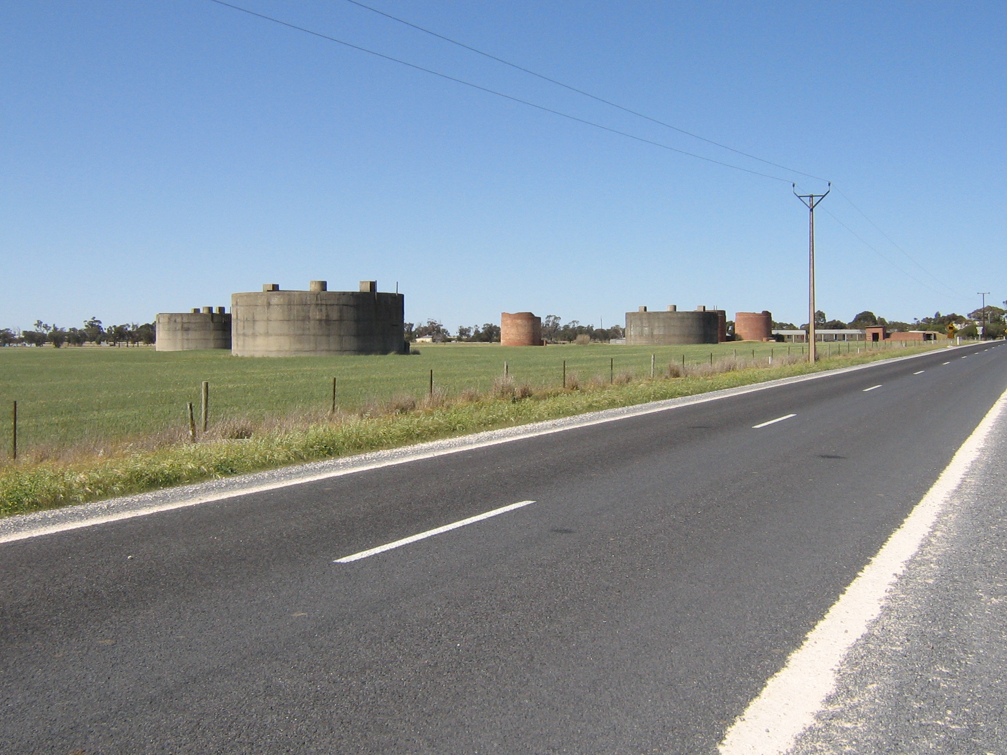
caption = World War II fuel tanks
lga =
postcode = 5269 [ [http://www1.auspost.com.au/postcodes/index.asp?Locality=wolseley&sub=1&State=&Postcode=&submit1=Search Wolseley Postcode] Australia Post. Retrieved on 2008-05-29]
est =
pop = 341 (2006 Census) [ [http://www.censusdata.abs.gov.au/ABSNavigation/prenav/LocationSearch?locationLastSearchTerm=Wolseley&locationSearchTerm=Wolseley&newarea=SSC45376&submitbutton=View+QuickStats+%3E&mapdisplay=on&collection=Census&period=2006&areacode=SSC45376&geography=&method=Place+of+Usual+Residence&productlabel=&producttype=QuickStats&topic=&navmapdisplayed=true&javascript=true&breadcrumb=PL&topholder=0&leftholder=0¤taction=104&action=401&textversion=false&subaction=1 Australian Bureau of Statistics (25 October 2007)] . Wolseley(State Suburb). "2006 Census Quickstats". Retrieved on 2008-05-29]
elevation=
maxtemp =
mintemp =
rainfall =
stategov = Goyder
fedgov = Grey
dist1 = 289
dir1 = South East
location1= Adelaide via
Wolseley (coord|36|21|S|140|54|E|region:AU-SA_type:city) is a small South Australian town near the Victorian border. It is five kilometres south of the Dukes Highway and 13 kilometres east of Bordertown. It was first proclaimed a town in 1884.
A broad (1600 mm) gauge railway was opened to Adelaide and Melbourne in 1886. Some years later the Millicent - Mount Gambier narrow (1067 mm) gauge railway was extended to Wolseley, creating a break-of-gauge rail junction. In the 1950s the break-of-gauge was abolished by the conversion of the Mount Gambier line to broad gauge. The line to Mount Gambier has been out of use since the conversion of the Adelaide - Melbourne line to standard (1435 mm) gauge in 1995, pending possible conversion to standard gauge.
Early in World War II, No. 12 Inland Aircraft Fuel Depot was established at Wolseley, with an initial capacity of 280,000 gallons (approx 1,273,000 litres) in three tanks camouflaged to look like farm buildings. The depot started operations in 1942 and three additional tanks were added later. It was disbanded on 14 June 1944. [Interpretative sign at the site west of Wolseley]
Wolseley is in the Tatiara District Council, the state electoral district of MacKillop and the federal Division of Barker.
References
External links
* [http://www.tatiara.sa.gov.au/site/page.cfm?u=150&print=1 Tantiara Council, "Wolseley"]
Wikimedia Foundation.
2010.
Look at other dictionaries:
Rail transport in South Australia — South Australia was the first colony in Australia to build a railway line. It was a horse drawn tramway from the port of Goolwa on the Murray River to an ocean harbour at Port Elliot in 1854. Today the state has RailGauge|1600 broad gauge… … Wikipedia
Wolseley — can refer to:People*Garnet Wolseley, 1st Viscount Wolseley *Wolseley BaronetsBusinesses*Wolseley plc, a British distributor of building supplies that was formerly active in other sectors *Wolseley Motor Company, an automobile spun off in 1901… … Wikipedia
Eisenbahn in South Australia — Kapspurige Dampflokomotive Nr. 9 der V Klasse der South Australian Railways von 1877. Heute aufgestellt als Denkmallokomotive in Naracoorte Die Eisenbahn in South Australia zeichnet sich durch eine – selbst für australische Verhältnisse – üppige… … Deutsch Wikipedia
Wolseley — bezeichnet: Wolseley Motor Company, einen ehemaligen englischen Fahrzeughersteller Wolseley (Unternehmen), ein britisches Unternehmen Wolseley (Südafrika), eine Stadt in Südafrika Wolseley (South Australia), ein Ort in Australien Wolseley ist der … Deutsch Wikipedia
List of cities and towns in South Australia — This is a list of town and locality names in South Australia outside of the metropolitan postal area of Adelaide.:For a list of suburbs in metropolitan areas of Adelaide, see lists inside following individual city council articles: City of… … Wikipedia
List of postcodes in South Australia/numeric sort — Postcodes are used by Australia Post to identify postal districts in Australia. This list is sorted numerically to facilitate seeing which towns/suburbs share a postcode.5000s inner suburbs* 5000 Adelaide * 5001 GPO Boxes * 5005 University of… … Wikipedia
South African Wars (1879-1915) — Ethnic, political and social tensions among European colonial powers, indigenous Africa, and English and Dutch settlers led to open conflict in a series of wars and revolts between 1879 and 1915 that would have lasting repercussions on the entire … Wikipedia
Point Piper, New South Wales — Infobox Australian Place | type = suburb name = Point Piper city = Sydney state = nsw caption = Seven Shillings Beach lga = Municipality of Woollahra postcode = 2027 pop = 1,386 (2001) [Census 2001 AUS|id=SSC12926|name=Point Piper (State… … Wikipedia
Rail transport in Australia — is to a large extent state based. The Australian rail network consists of a total of 33,819 km of track of three major gauges, of which 2,540 km is electrified. Fact|date=March 2008The majority of the Australian railway network infrastructure is… … Wikipedia
Rail gauge in Australia — displays much variation, which is an ongoing problem for transportation on the continent.The most used gauges are * Irish gauge RailGauge|1600 4,017 km mainly Victoria, some South Australia * Standard gauge RailGauge|1435 17,678 km mainly New… … Wikipedia