- Church of St Andrew, Goldsworth Park
-
Coordinates: 51°19′08″N 0°35′28″W / 51.319°N 0.591°W
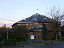

St. Andrew's Church is the parish church of Goldsworth Park, a district of Woking, Surrey, England.
It is a parish of the Church of England and was created to serve the Goldsworth Park Estate, a major greenfield housing development bounded by St. John's, Knaphill and Horsell. The first vicar was appointed in 1981, and the church met in local schools before moving into its purpose-designed St. Andrew's Church Centre in 1988. The building is situated at Goldsworth Park Centre, adjacent to the local shops and health centre.
St Andrew's Church opened its A2 Youth & Community Centre in 2008, providing youth facilities and venues for local community and social events. The A2 is located adjacent to the Church Centre.
External links
Categories:- Church of England churches in Surrey
- Woking
- United Kingdom church stubs
- Surrey geography stubs

Wikimedia Foundation. 2010.