- Bruning Army Airfield
Infobox Airport
name = Bruning Army Airfield
(Closed)
nativename =
nativename-a =
nativename-r =
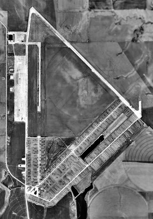
image-width =
caption =
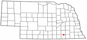
image2-width =
caption2 =
IATA =
ICAO =
FAA =
LID =
type =
owner =
operator =
owner-oper =
city-served =
location =
elevation-f =
elevation-m =
coordinates =
website =
metric-elev =
metric-rwy =
r1-number = 17/35
r1-length-f = 6,800
r1-length-m = 2,072
r1-surface = Concrete
Not Usable
r2-number = 13/31
r2-length-f = 6,800
r2-length-m = 2,072
r2-surface = Concrete
Not Usable
r3-number = 04/22
r3-length-f = 6,800
r3-length-m = 2,072
r3-surface = Concrete
Not Usable
stat-year =
stat1-header =
stat1-data =
footnotes =Bruning Army Airfield was a flight training installation of the
United States Army Air Forces used during theSecond World War and located in northeast Thayer County,Nebraska , at latitude 40°21'25" North, 97°25'42" West, approximately six miles east of Bruning.History
Bruning AAF was one of eleven
United States Army Air Force training bases inNebraska duringWorld War II . The base was under the command ofSecond Air Force Headquarters,Colorado Springs ,Colorado , and provided final training for Consolidated B-24 Liberator Heavy Bombers and Republic P-47 Thunderbolt Fighter-Bombers.Land for Bruning was purchased by the USAAF on
September 12 ,1942 , from local farmers for $73,400. Approximately 1,000 construction workers were used to build the field on 1,720 acres (7 km²) of land, with an additional 2,122 acres (9 km²) south of the base leased for a gunnery range. At its peak of activity Bruning had 3,077 military and 500 civilian personnel assigned.The base consisted of three runways of 6,800 feet (2,070 m) in length, formed in a triangle, with the main parking apron (600 by 2,135 ft) located on the north-south (17/35)
runway . Three hangars and 231 support buildings were constructed. The base was activated onMarch 18 ,1943 , and dedicated onAugust 28 ,1943 . The first unit arrived for training onAugust 2 ,1943 .The following units trained at Bruning AAF:
*456th Bomb Group -August 2 -October 8 ,1943
Sent To 15th Air Force in Italy, (B-24 Liberator )
*449th Bomb Group -September 12 -December 3 1943
Sent To 15th Air Force in Italy, (B-24 Liberator )
*487th Bomb Group -September 20 -December 15 ,1943
Sent To 8th Air Force in England, (B-24 Liberator )
*23d Fighter Squadron - November 1943 - March 1944
(Part of 36th Fighter Group at Scribner AAF NE)
Sent to 9th Air Force in England (P-47 Thunderbolt )
*507th Fighter Group -October 20 -December 12 ,1944
Sent To 20th Air Force in Okinawa, (P-47 Thunderbolt )
*508th Fighter Group -November 15 -December 18 ,1944
Sent To Hawaii as replacement training group, (P-47 Thunderbolt )The host unit at the airfield was the 510th Headquarters and Air Base Squadron (Later 510th Army Air Force Base Unit). The 510th was assigned to the 16th Bombardment Operational Training Wing (July - Dec 1943), then was transferred to the 72nd Fighter Wing in December 1943.
Local historians record that 23 airmen died in training accidents at the base, and an additional 28 were killed on
August 4 ,1944 , when aC-47 Skytrain carrying a graduating class of fighter pilots ran into a thunder storm and crashed near Naper, NE killing all 28 men.The base was declared surplus by the USAAF on
November 21 ,1945 and turned over to the State of Nebraska. It served as a civilairport (Bruning State Airport) until 1969, although gradually all but a small portion of one runway were closed.Bruning Army Airfield is now abandoned and only the large Sub-Depot hangar is still standing. The North-South and SW-NE runways are used as the home of Mid-America Feed Yard, a large commercial cattle feed lot, and the NW-SE runway is still visible.
On
July 19 ,1998 the Thayer County Historical Society dedicated a Nebraska State Historical Monument on Highway 4 about 6 miles (10 km) east of the town of Bruning NE near the site of the Bruning Army Air Field.See also
*
Second Air Force
*United States Army Air Force
*Nebraska World War II Army Airfields References
* [http://armyairforces.com ArmyAirForces.Com]
* Maurer Maurer, "Air Force Combat Units Of World War II", Office of Air Force History, 1983External links
* [http://www.airfields-freeman.com/NE/Airfields_NE_SE.htm#bruning Abandoned & Little-Known Airfields: Western Nebraska]
* [http://maps.google.com/maps?q=Bruning,+NE&ie=UTF8&z=13&ll=40.339348,-97.42753&spn=0.056263,0.167027&t=h&om=1 Image of Bruning Army Airfield on Google Earth]
* [http://www.midamerica-feedyard.com/ Mid-America Feedyard]
Wikimedia Foundation. 2010.