- Ottersberg
-
Ottersberg 

 OttersbergLocation of Ottersberg within Verden district
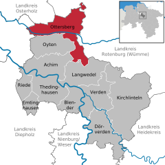

Coordinates 53°06′N 9°09′E / 53.1°N 9.15°ECoordinates: 53°06′N 9°09′E / 53.1°N 9.15°E Administration Country Germany State Lower Saxony District Verden Mayor Horst Hofmann (CDU) Basic statistics Area 99.03 km2 (38.24 sq mi) Elevation 14 m (46 ft) Population 12,055 (31 December 2010)[1] - Density 122 /km2 (315 /sq mi) Other information Time zone CET/CEST (UTC+1/+2) Licence plate VER Postal code 28870 Area code 04205 Website www.flecken-ottersberg.de Ottersberg is a municipality in the district of Verden, in Lower Saxony, Germany. It is situated approx. 20 km north of Verden, and 28 km east of Bremen.
Contents
History
Ottersberg belonged to the Prince-Archbishopric of Bremen, established in 1180. In 1648 the Prince-Archbishopric was transformed into the Duchy of Bremen, which was first ruled in personal union by the Swedish Crown - interrupted by a Danish occupation (1712–1715) - and from 1715 on by the Hanoverian Crown. The Kingdom of Hanover incorporated the Duchy in a real union and the Ducal territory became part of the new Stade Region, established in 1823.
Geography
Ottersberg lies on a sandy ridge, part of a glacial morraine in the valley of the Wümme. In winter the lowland areas are often under water for weeks at a time and form a valuable bird sanctury of international importance. It lies on the A 1 road between Bremen and Hamburg. The Bremen - Hamburg railway line originally passed south the village. After the second world war the district around the station developed to the south of the railway line. The station is called Ottersberg (Hanover), because it lies in the historical country of Hanover.
Local government
Since the local administrative and territorial reforms of 1972, there is a unified community called Flecken Ottersberg consisting of the hamlets of Ottersberg itself plus Fischerhude, Quelkhorn, Otterstedt, Posthausen, Eckstever and Narthauen.
After the September 2006 municipal elections the council consisted of the 6 Group -- Social Democratic Party of Germany 8 members Christian Democratic Union of Germany 11 members. , Alliance 90/The Greens 3 members, Green List Ottersberg 2 members, Free Democratic Party 1 member, Free citizens Otterberg 3 members. The full-time mayor is directly elected.
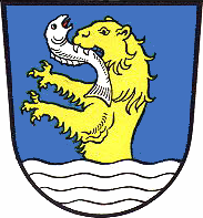
Town crest
The crest is a rising up from the water of an otter with fish in its mouth) on a blue background. The otter is not presented naturalistically, but as a modified otter with a heraldic lion's head and claws.
Education
Ottersberg is the seat of Ottersberg College which offers bachelor's degrees in social art, Art Therapy, theater , social studies and Fine Art. Since 1946 the Free Rudolf Steiner school of Ottersberg has occupied the site of the former castle. The embankments and ditch of the castle remain in evidence.
Culture
The artist Otto Modersohn (1865–1943) lived in Ottersberg and is buried in the churchyard at Quelkhorn.
A Jewish Cemetery lies on the road between Otterstedt and Ottersberg, which has 27 Tombstones of Jews from the Ottersberg region who died between the years 1835 and 1920. The cemetery is a protected Cultural relic.
References
- ^ "Bevölkerungsfortschreibung" (in German). Landesbetrieb für Statistik und Kommunikationstechnologie Niedersachsen. 31 December 2009. http://www1.nls.niedersachsen.de/statistik/html/parametereingabe.asp?DT=K1000014&CM=Bev%F6lkerungsfortschreibung.
External links
- municipal website accessed February 2010
- Freie-Rudolf-Steiner-Schule accessed February 2010
Achim | Blender | Dörverden | Emtinghausen | Kirchlinteln | Langwedel | Ottersberg | Oyten | Riede | Thedinghausen | Verden Categories:
- Municipalities in Lower Saxony
- Lüneburg region geography stubs


Wikimedia Foundation. 2010.