- Ayutthaya
Infobox Settlement
name = Phra Nakhon Si Ayutthaya
official_name =
other_name =
native_name = พระนครศรีอยุธยา
nickname =
settlement_type =
total_type =
motto =
imagesize =
image_caption =
flag_size =
image_
seal_size =
image_shield =
shield_size =
image_blank_emblem =
blank_emblem_type =
blank_emblem_size =
mapsize =
map_caption =
mapsize1 =
map_caption1 =
image_dot_
dot_mapsize =
dot_map_caption =
dot_x = 151 |dot_y = 65
pushpin_
pushpin_label_position =
pushpin_map_caption =
pushpin_mapsize =
subdivision_type = Country
subdivision_name =Thailand
subdivision_type1 = Province
subdivision_name1 = Ayutthaya
subdivision_type2 =
subdivision_name2 =
seat_type =
seat =
parts_type =
parts_style =
parts =
p1 =
p2 =
government_footnotes =
government_type = City municipality
leader_title = Mayor
leader_name = Somsong Sappakosonlakul
leader_title1 =
leader_name1 =
established_title =
established_date =
area_magnitude =
unit_pref =
area_footnotes =
area_total_km2 = 14.84
area_land_km2 =
area_water_km2 =
area_total_sq_mi =
area_land_sq_mi =
area_water_sq_mi =
area_water_percent =
elevation_footnotes =
elevation_m =
elevation_ft =
elevation_max_m =
elevation_max_ft =
elevation_min_m =
elevation_min_ft =
population_as_of = 2006
population_footnotes =
population_note = Registered residents only
population_total = 54888
population_density_km2 = auto
population_density_sq_mi =
timezone = Thailand
utc_offset = +7
timezone_DST =
utc_offset_DST =
coor_type =
latd= |latm= |lats= |latNS=
longd= |longm= |longs= |longEW=
postal_code_type =
postal_code =
area_code =
blank_name =
blank_info =
website = [http://www.ayutthayacity.go.th/ www.ayutthayacity.go.th/]
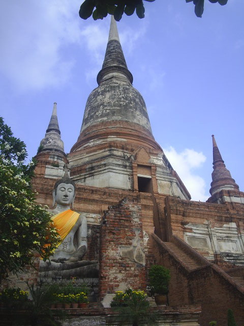
footnotes =Ayutthaya (full name Phra Nakhon Si Ayutthaya, _th. พระนครศรีอยุธยา, IPA2|aˡjutʰajaː; also spelled "Ayudhya") city is the capital of
Ayutthaya province inThailand . The city was founded in1350 by King U-Thong, who came here to escape asmallpox outbreak inLop Buri , and proclaimed it the capital of his kingdom, often referred to as theAyutthaya kingdom or Siam. Ayutthaya was named after the city ofAyodhya inIndia , the birthplace ofRama in the "Ramayana " (Thai, "Ramakien "). In1767 the city was destroyed by the Burmese army, and the ruins of the old city now form theAyutthaya historical park , which is recognized internationally as aUNESCO World Heritage Site . The city was refounded a few kilometers to the east.It is estimated that Ayutthaya around ca. 1600 had a population of ca. 300,000, and even 1,000,000 around 1700. In that era Ayutthaya belonged thus to the world's largest cities. [
George Modelski , "World Cities: –3000 to 2000", Washington DC: FAROS 2000, 2003. ISBN 2-00309-499-4. See also [http://faculty.washington.edu/modelski/ Evolutionary World Politics Homepage] .]Ayutthaya Town Center
*Ayutthaya Historical Study Center
*Chan Kasem Palace
*Chao Sam Phraya National Museum
*St. Joseph's Church
*Wang Luang
*Wat Chai Watthanaram
*Wat Lokaya Sutharam
*Wat Mahathat
*Wat Na Phra Men
*Wat Phanan Choeng
*Wat Phra Ram
*Wat Phra Si Sanphet
*Wat Phutthaisawan
*Wat Ratchaburana
*Wat Suwan Dararam
*Wat Thammikarat
*Wihan Phra Mongkhon BophitThe city is located at the junction of the
Chao Phraya , Lopburi and Pa Sak rivers, and on the main north-south railway linkingChiang Mai toBangkok . The old city is on an island formed by a bend of the Chao Phraya on the west and south sides, the Pa Sak on the east side and, on the northern side, the Klong Maung canal.Approximate centre of the old city: coord|14|20|N|100|34|E
The Empire was actually brought down in 1767 by the Burmese destruction of Ayudhya.
Media
In popular culture
*A Thailand-themed town named "Ayothaya" appears in the PC
MMORPG "Ragnarok Online .References / External links
* [http://www.ianandwendy.com/OtherTrips/ThailandMalaysia/Thailand/index.htm Photos and Videos of Ayutthaya]
*
Wikimedia Foundation. 2010.
