Bab Iskender

Bab Iskender
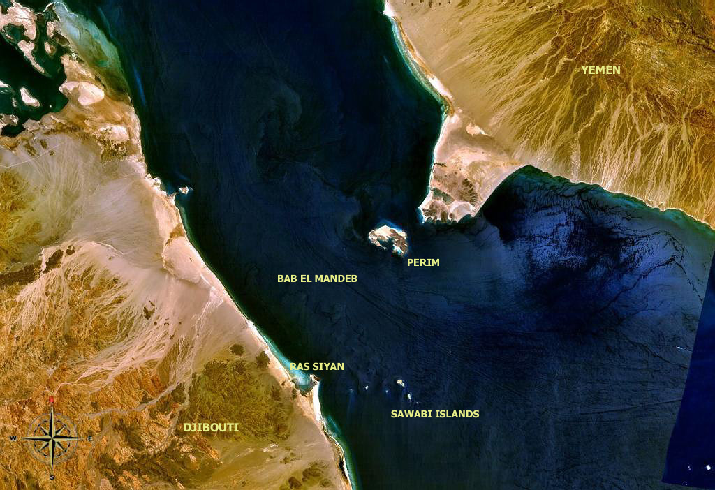
Bab-el-Mandeb area with description

The Bab Iskender (Arabic: باب اسكندرIskander's Strait) is the eastern section 2 miles (3.2 km) wide and 16 fathoms (29 m) of the Bab-el-Mandeb straits, which separates Ras Menheli, Yemen, on the Arabian Peninsula and Ras Siyan, Djibouti, on the Horn of Africa. The Yemeni island of Perim divides the strait into two channels, Bab Iskender and Dact-el-Mayun respectively.

The western section of the straits, Dact-el-Mayun, has a width of about 16 miles (26 km) and a depth of 170 fathoms (310 m).

Near the African coast lies a group of smaller islands known as the Seven Brothers.

The straits are about 20 miles (32 km) wide in total.

Coordinates: 12°40′N 43°27′E / 12.667°N 43.45°E / 12.667; 43.45


Wikimedia Foundation. 2010.

Игры ⚽ Поможем решить контрольную работу

Look at other dictionaries:

  • Bab el Mandeb — Vue satellite du détroit de Bab el Mandeb. Profondeur 310 m (max) Type Détroit Localisation Mer Rouge Golfe d Aden ( …   Wikipédia en Français

  • Bab-el-Mandeb — Basin countries  Yemen …   Wikipedia

  • Bab-el-Mandeb — Vue satellite du détroit de Bab el Mandeb. Géographie humaine Pays côtier(s) …   Wikipédia en Français

  • List of Yemen-related topics — This is a list of topics related to Yemen. Yemen* Yemen * A New Day in Old Sana a * Culture of Yemen * Greater YemenCities in Yemen* List of cities in Yemen * Aden * Ahwar * Al Qasha * Baraqish * Al Bayda , Yemen * Beihan * Ad Dali * Dhamar,… …   Wikipedia

  • Perim — بريم (ar) Image satellite de Perim dans le détroit de Bab el Mandeb …   Wikipédia en Français

  • Barim — Perim Perim بريم (ar) Image satellite de Perim dans le détroit de Bab el Mandeb. Géographie …   Wikipédia en Français

  • Barīm — Perim Perim بريم (ar) Image satellite de Perim dans le détroit de Bab el Mandeb. Géographie …   Wikipédia en Français

  • Mayyun — Perim Perim بريم (ar) Image satellite de Perim dans le détroit de Bab el Mandeb. Géographie …   Wikipédia en Français

  • Meyo — Perim Perim بريم (ar) Image satellite de Perim dans le détroit de Bab el Mandeb. Géographie …   Wikipédia en Français

  • Perim Island High Light — Perim Perim بريم (ar) Image satellite de Perim dans le détroit de Bab el Mandeb. Géographie …   Wikipédia en Français

Share the article and excerpts

Direct link
Do a right-click on the link above
and select “Copy Link”