- Cerro de la Estrella
-
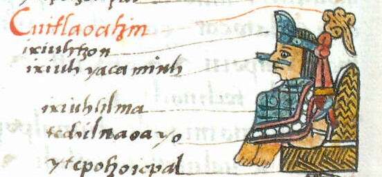
 Cuitláhuac, Iztapalapa Lord, became tlatoani upon the death of Motecuhzoma Xocoyotzin. He died from smallpox in 1520.

Cerro de la Estrella is a mesoamerican archaeological site located in southeastern Central Mexico's Valley of Mexico, in the Iztapalapa delegación (borough) of the Mexican Federal District at an elevation of 2460 meters (8070ft) above sea level, hence its Summit is 224 m over the Valley of Mexico level.[1] At the southeast edge of what was the Great Texcoco Lake.
Historical sources establish that ancient inhabitants of the Mexican Plateau knew this place as Huizachtecatl. The site was very important since the “New Fire” ritual ceremony was performed here; it had a profound meaning for the population here and in surrounding regions.[2]Contents
Occupation stages
The oldest traces of human occupation in the Iztapalapa territory originated at Santa María Aztahuacan village. In 1953 remains of two individuals were found and, according to analysis performed by National University of Mexico (UNAM) and of y del Instituto Nacional de Antropología e Historia these human remains are approximately nine thousand years old.[3]
More recent archaeological materials indicate continued occupation of the Cerro de la Estrella slopes, at least from the Preclassical period. At that time, a village related to the Cuicuilco culture was established here. This culture decline, in the South of the Valley of Mexico, occurred approximately in 8th century CE, and was possibly linked to the eruption of the Xitle volcano.[3]
Towards the end of the Preclassical period commenced occupation by Culhuacán. During the classical period, Culhuacán, as most cities in the Valley of Mexico and Mesoamerica, was part of a trade system centered in Teotihuacan. After the fall of this city, approximately in the 8th century d. C., some of its inhabitants took refuge in the ancient coastal towns of Texcoco Lake such as Culhuacán. A cultural Teotihuacan haven remained there, later merged with warrior peoples, migrating towards the center of México.[3]
Site
Archeological investigations reveal indications of constructions built as early as 100 to 650 AD, and it was inhabited from the mid preclassical period (1000 AD) up to the Spaniards arrival. First settlers of the site used the Huizachtecatl slopes, where villages were founded; they had early farming systems and had a rudimentary social organization It is believed that these groups made the stone glyphs found in the place known as “Cerro Chiquito” or small hill.[2]
Ceramic and stone sculpture materials were discovered in the west side of Huizachtecatl that apparently was made within the 100 to 500 years AD; these resemble other similar pieces found in Zacatenco, north of México City. The constructions here were built between the year 100 and 650 AD and are located in the North side, the remains consist of foundations and walls of palaces that indicate Teotihuacán’s influence.[2]
Archaeological evidence reveals the existence of a housing zone in the middle of the hill, built during the late Classic period (600 to 900 AD). At that time numerous civil type structures were constructed because of the increased population. Unfortunately, remains are lost under present constructions.[2]
Sahagún, Motolinia, Torquemada and the Cuautitlán Annals, among other sources, indicate that between the period 900 to 1300 AD, the chichimeca were based in the west side of the hill, where they founded the town of Colhuacan. These settlers achieved important technological and social development; apparently a theocratic system prevailed and later by a dynasty of kings. Between years 1300 and 1521 AD, the mexicas invaded the area, and to control their people, they founded the town of Ixtapalapa that together with Colhuacan, served to protect the south of the great Tenochtitlan and to provide staples to the larger city. It is known that at that time the platforms the top of the hill were constructed.[2]
New Fire ceremony
The mexicas conceived the universe as a four petal great flower of, at the center of which was the great Tenochtitlan. Each petal represented one of the four cardinal points; the region to the east was symbolized by the acatl glyph (cane), the west by calli (house), the north by tecpatl (flint stone knife) and the south by tochitl (rabbit). As an inherited Toltec tradition, they worshiped the Sun, deity that governed life of all beings and thought that human hearts were required to please him in addition to the blood on prisoner soldiers.[2]
For that reason, every 52 years, when the beginning of the calendars (Civil and Religious) coincided, the sacerdotal class performed the New Fire ceremony, to prevent the Sun’s death, as they thought, would cause total darkness of the universe, allowing the sprouting of tsitsimeme, entities that ate human beings.[2]
At dusk of the great day the main priests wore their best clothes and headed by the priest of Copilco, went to the top of Huizachtecatl to initiate the ceremony. Previously, a prisoner was placed in the main temple altar, and when the time came, a log or mamahuastli was placed on his chest and set on fire to ignite the New Fire; meanwhile, the great Tenochtitlan and towns surrounding the great lake remained in complete darkness. The Copilco priest took the fire from the chest and transmitted it to a bonfire. Later the prisoner was sacrificed, his heart extracted and thrown into the flames. There were messengers responsible to deliver torches lit with the New Fire to priests of towns that had attended the ceremony at Huizachtecatl.[2]
At the great Tenochtitlan the fire was placed before the main deity, from where it was taken to other Gods temples, and from there to people’s quarters.
Based on archeological investigations, Colhuas were the first to use the top of the hill for the New Fire or Toxiuhmopolli ceremony; historical sources indicate that four such ceremonies took place; in 1351, 1403, 1455 and 1507. The great Tenochtitlan was conquered before the fifth ceremony could take place.[2]
References
- ^ INEGI (1995): Topographical Chart' (Spanish).
- ^ a b c d e f g h i "Méndez Martínez, Enrique Cerro de la Estrella, INAH Official Web Page" (in Spanish). INAH. http://www.gobiernodigital.inah.gob.mx/ZonasArqueologicas/todas/htme/za00702.html. Retrieved September 2010.
- ^ a b c WP Iztapalapa Municipality Web Page (Spanish)
External links
Further reading
- Blanton, Richard E. (1972). "Prehistoric Settlement Patterns of the Ixtapalapa Region, Mexico". Occasional Papers in Anthropology (University Park, PA.: Department of Anthropology, Pennsylvania State University) 6.
- Montero García, Ismael Arturo (Ed.) (2002). Huizachtepetl: geografía sagrada de Iztapalapa. Mexico City: Delegación Iztapalapa.
- Ramírez Acevedo, Gilberto (2003). "Reporte de la exploración del sitio arqueológico en la cima del Cerro de la Estrella (Huixachtecatl): el templo pirámide del "Fuego nuevo"". Arqueología 30: 155–167.
Categories:- Mesoamerica
- Archaeological sites in Mexico
- Mesoamerican sites
- Archaeological sites in Mexico City
- Former populated places in Mexico
- Buildings and structures in Mexico City
- 5th-century BC architecture
- Aztec sites
Wikimedia Foundation. 2010.