Worrall Covered Bridge

Worrall Covered Bridge

Infobox_nrhp | name =Worrall Covered Bridge
nrhp_type =


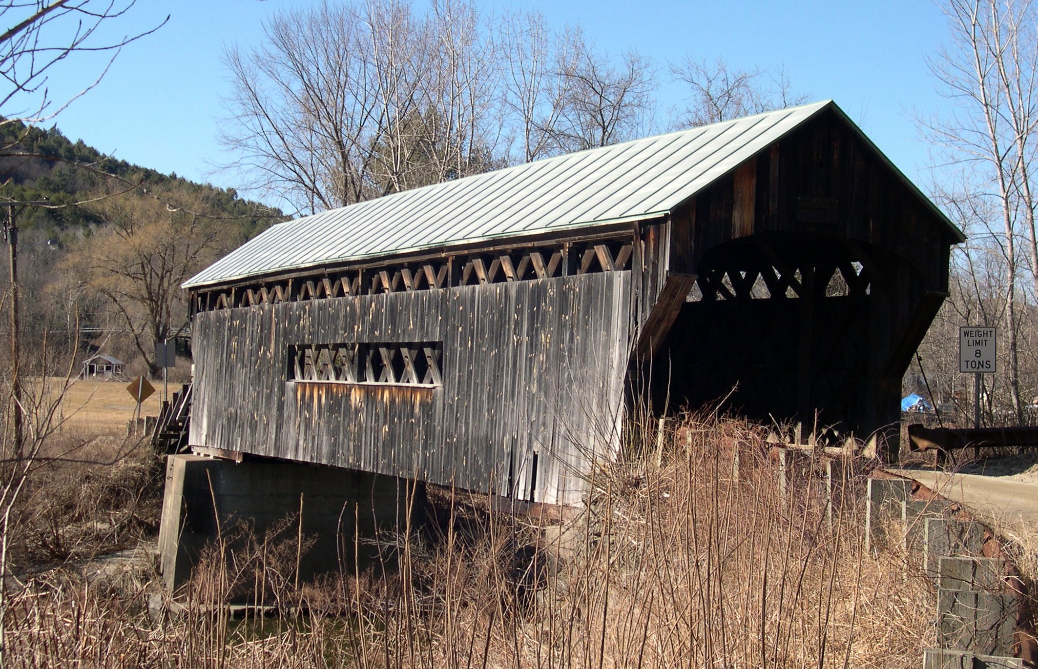
caption =The Southeast approach to the Worrall bridge. Note the rare wooden ramp on the opposite end.
nearest_city= Rockingham, Vermont
lat_degrees = 43 | lat_minutes = 12 | lat_seconds = 41.77 | lat_direction = N
long_degrees = 72 | long_minutes = 32 | long_seconds = 8.74 | long_direction = W
area =
built =1870
architect= Granger,Sanford
architecture= Other
added = July 16, 1973
governing_body = Local
refnum=73000209 cite web|url=http://www.nr.nps.gov/|title=National Register Information System|date=2007-01-23|work=National Register of Historic Places|publisher=National Park Service]
The Worrall Covered Bridge (also called the Woralls Bridge) is a covered bridge in Rockingham, Vermont, United States. Built in 1868 by Sanford Granger, the bridge is a lattice style with an 87 foot span across the Williams River. The bridge is listed on the National Register of Historic Places.

The Worrall bridge includes one rare feature - a wooden ramp leading up to the northwest entrance. It is located on Williams Road, a dirt road a short distance north of Vermont Route 103. Nearby, to the west, is the Bartonsville Covered Bridge, also built by Granger.

References

External links


Wikimedia Foundation. 2010.

Игры ⚽ Поможем написать реферат

Look at other dictionaries:

  • Bartonsville Covered Bridge — Infobox nrhp | name =Bartonsville Covered Bridge nrhp type = caption =The Northeast approach to the Bartonsville bridge location= Bartonsville, Vermont lat degrees = 43 | lat minutes = 13 | lat seconds = 27.23 | lat direction = N long degrees =… …   Wikipedia

  • Lattice truss bridge — A lattice bridge is a form of truss bridge that uses a large number of small and closely spaced diagonal elements that form a lattice. It was patented by architect Ithiel Town in 1820 and 1835 as Town s lattice truss.Originally a design to allow… …   Wikipedia

  • National Register of Historic Places listings in Windham County, Vermont — Location of Windham County in Vermont This is a list of the National Register of Historic Places listings in Windham County, Vermont. This is intended to be a complete list of the properties and districts on the National Register of Historic… …   Wikipedia

  • Vermont Route 103 — Infobox road state=VT type=VT route=103 length mi=42.036 length ref=cite web |url=http://www.aot.state.vt.us/Planning/Documents/TrafResearch/Publications/2006%20Route%20Log%20AADTs%20State%20Highways Final.pdf |title=2006 (Route Log) AADTs State… …   Wikipedia

  • Rockingham, Vermont — Infobox Settlement official name = Rockingham, Vermont settlement type = Town nickname = motto = imagesize = 250px image caption = Pleasant Valley Grange Hall, next to the Rockingham Meeting House image mapsize = 250px map caption = Rockingham,… …   Wikipedia

  • Australian Idol (season 2) — Australian Idol Season 2 Broadcast from 13 July 2004–21 November 2004 Judges Ian Dicko Dickson Marcia Hines Mark Holden Host(s) Andrew G James Mathison …   Wikipedia

  • Lydbrook — infobox UK place official name= Lydbrook latitude= 51.84 longitude= 2.58 shire district= Forest of Dean shire county = Gloucestershire region= South West England country= England constituency westminster= Forest of Dean post town= LYDBROOK… …   Wikipedia

  • Grimsby — For other uses, see Grimsby (disambiguation). Coordinates: 53°33′34″N 0°04′05″W …   Wikipedia

  • Methodist College Belfast — Motto Deus Nobiscum (God With Us) Established 1865 Head …   Wikipedia

  • Wadsley — infobox UK place country = England official name= Wadsley population= 5,631 [ [http://www.sheffield.gov.uk/EasySite/lib/serveDocument.asp?doc=87147 pgid=102295 Sheffield City Council Wadsley] ] latitude= 53.41 longitude= 1.52 metropolitan borough …   Wikipedia

Share the article and excerpts

Direct link
Do a right-click on the link above
and select “Copy Link”