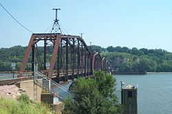
Dubuque Rail Bridge

Dubuque Rail Bridge
Dubuque Rail Bridge

The Dubuque Railroad Bridge.
Carries Single rail track
Crosses Mississippi River
Locale Dubuque, Iowa and East Dubuque, Illinois
Maintained by Canadian National Railway
Design Truss Bridge with Swing-span
Opened December 1868
Coordinates 42°29′55″N 90°39′01″W / 42.49861°N 90.65028°W / 42.49861; -90.65028

The Dubuque Rail Bridge carries a single rail line across the Mississippi River between Dubuque, Iowa, and East Dubuque, Illinois, near river mile 580. The original swing bridge was constructed by Andrew Carnegie and operated by the Dunleith & Dubuque Bridge Company opening in December 1868,[1] primarily used by the Illinois Central Railroad. The bridge was rebuilt in the 1890s and has 5 spans and a swing-span. It is currently operated by Canadian National Railway as a result of their purchase of Illinois Central in 1999.

See also

References

External links


Wikimedia Foundation. 2010.

Игры ⚽ Нужен реферат?

Look at other dictionaries:

  • Dubuque–Wisconsin Bridge — Dubuque Wisconsin Bridge A view of the bridge from Riverview Park, Dubuque Other name(s) City Island Bridge Carries 4 lanes of U.S. Route 61/U.S. Route 151 …   Wikipedia

  • Dubuque-Wisconsin Bridge — Infobox Bridge bridge name= Dubuque Wisconsin Bridge caption= A view of the bridge from Riverview Park, Dubuque official name= also known as= City Island Bridge carries= 4 lanes of U.S. Route 61/U.S. Route 151 crosses= Mississippi River locale=… …   Wikipedia

  • Dubuque, Iowa —   City   Downtown Dubuque, Iowa, Oct 2008 …   Wikipedia

  • Port of Dubuque — The Port of Dubuque (also known as the Ice Harbor, 4th Street Peninsula, or the Riverfront) is the section of downtown Dubuque, Iowa that lies immediately adjacent to the Mississippi River. The area was among the first areas settled in what would …   Wikipedia

  • Julien Dubuque Bridge — Infobox Bridge bridge name= Julien Dubuque Bridge caption= Julien Dubuque Bridge, late 1980s official name= also known as= High Bridge carries= 2 lanes of U.S. Route 20 1 pedestrian walkway crosses= Mississippi River locale= Dubuque, Iowa, and… …   Wikipedia

  • Norwottuck Rail Trail — Looking east from the western trail head Length 9.5 miles (15 km) Location Northampton, Massachusetts to Belchertown, Massachusetts …   Wikipedia

  • Savanna-Sabula Bridge — Infobox Bridge bridge name= Savanna Sabula Bridge caption= May, 2004 official name= also known as= carries= 2 lanes of U.S. Route 52/Iowa Highway 64/IL 64 crosses= Mississippi River locale= Savanna, Illinois and Sabula, Iowa, Iowa Illinois… …   Wikipedia

  • Natural Bridge State Park (Massachusetts) — Natural Bridge State Park Massachusetts State Park …   Wikipedia

  • Dan Patch Line Bridge — The swing span as seen from the north (Bloomington) side of the river. The bridge is in its open position. Carries One rail crossing; formerly two traffic lanes Crosses Minnesot …   Wikipedia

  • Nashua River Rail Trail — The Nashua River Rail Trail at the Groton School Pond in Groton, MA The Nashua River Rail Trail is a 12.5 mile (20.1 km) paved mixed use rail trail in northern Massachusetts and southern New Hampshire under control of the Massachusetts… …   Wikipedia

Share the article and excerpts

Direct link
Do a right-click on the link above
and select “Copy Link”