- Catanduanes (island)
Infobox Islands
name = Catanduanes
image caption =
locator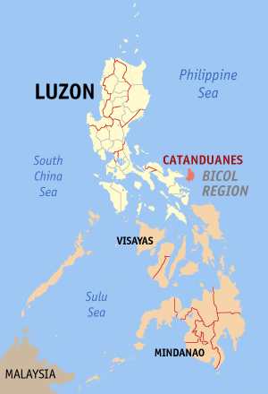
native name =
native name link =
location =South East Asia
coordinates =coord|13|48|N|124|16|E|region:PH_type:isle
archipelago =Philippine Islands
area = 1,511.50 km²
rank =
highest mount =
elevation =
country = Philippines
country admin divisions title = Municipalities
country admin divisions = Bagamanoc, Baras, Bato, Caramoran, Gigmoto, Pandan, Panganiban,San Andres ,San Miguel , Viga, Virac
country largest city =
country largest city population =
population = 232,757
population as of = 2007
density = 124
ethnic groups =Bicolano ,Tagalog Catanduanes is the main island of
Catanduanes Province .Catanduanes is known to many as an island paradise. It lies east of the
Bicol Peninsula . The island is bounded by theMaqueda Channel in the west, thePacific Ocean on the north and east, andLagonoy Gulf andCabugao Bay on the south.The general landscape of the island is hilly to mountainous, becoming more pronounced towards the central portion. Less than 10 percent of the land area has slope gradient under 8 percent, mostly fractured and narrow strips of plains dispersed near the coastal areas where most of the inhabitants are settled.
Catanduanes is also known as "Land of the Howling Winds" because it is frequently visited by a storm. But still, it has lots of beach resorts that is competitive enough.
Geography
The island of Catanduanes is located in 13°48′N, 124°16′E and east of the
Bicol Peninsula . The island is bounded in the north and west by thePhilippine Sea , in the south byLagonoy Gulf andCabugao Bay and in the east byMaqueda Channel Climate
Catanduanes' geographical position, lying completely open and unprotected within the
typhoon belt and facing directly the widePacific Ocean . Very often, it is overly exposed to off and on seasonal tropical storms which frequently visit the area every year.Catanduanes belongs to the second type of climate. It has no dry season with a very pronounce maximum rainfall from November to January.
ee also
*
Bicol Region
*Catanduanes Province
Wikimedia Foundation. 2010.