- Corn Island (Kentucky)
-
Coordinates: 38°15′44″N 85°45′33″W / 38.26222°N 85.75917°W
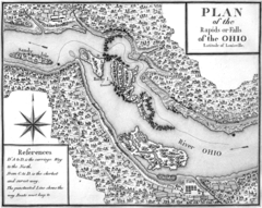
 An early map of the Falls of the Ohio, Corn Island is seen in the lower center
Corn Island is a now-vanished 7-acre (28,000 m2) island in the Ohio River, at head of the Falls of the Ohio, just north of Louisville, Kentucky.
Contents
Geography
Estimates of the size of Corn Island vary with time as it gradually was eroded and became submerged. A 1780 survey listed its size at 43 acres (170,000 m2). At that point it extended from what is now Louisville's Fourth Street to Fourteenth.[1]
The Louisville Cement Company extracted rock for cement in the 19th century, and the removal of trees from the island contributed to erosion, which combined to sink much of the island by 1895.[1] The island was flooded by the construction of a dam in the 1920s. It now lies permanently underwater.
History
Corn Island was first surveyed in 1773 by Thomas Bullitt's party and called Dunmore's Island (after John Murray, 4th Earl of Dunmore, Crown Governor of Virginia). Surveying expeditions like this helped to provoke Dunmore's War the following year.
During the American Revolutionary War, the island was settled on May 27, 1778 by George Rogers Clark's militia and 60 civilian settlers, who remained behind when Clark's party departed on June 24. Clark established the farming colony on the island as a communication post to support his famous military campaign in the Illinois Country.[2]
The island was renamed Corn Island by Clark, presumably reflecting the early importance of farming. The agricultural name also might have helped further the ruse that it was intended purely as a farming settlement, and not a military post. The settlers remained long after Clark's campaign ended. They moved to the mainland the following year, establishing Louisville. Louisville traces its foundation in 1778 to the settlement on Corn Island. The island continued to be used for farming and hunting until it was submerged.
Legacy
The annual Corn Island Storytelling Festival in September takes its name from the subject landmark. There is also a Sea Scout Group named The Corn Island Pirates in Louisville as well as a cultural resources survey company named Corn Island Archaeology, LLC.[3]
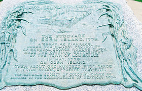
 Plaque commemorating Corn Island, standing next to Fort Nelson Park on the Louisville, Kentucky riverfront
See also
- Fort Nelson (Kentucky)
- Fort-on-Shore
- Fort William (Kentucky)
- Spring Station (Kentucky)
- Floyd's Station (Kentucky)
- Low Dutch Station
- Bryan's Station
- Station (frontier defensive structure)
- Geography of Louisville, Kentucky
- History of Louisville, Kentucky
References
- ^ a b English, William Hayden (1896). Conquest of the Country Northwest of the River Ohio 1778-1783. Bowen Merill. pp. 131–140. http://books.google.com/books?id=-EgSAAAAYAAJ&pg=PA136&dq=&as_brr=3&ei=DDtRSryDOYa4M5eRwNIC.
- ^ "225th Anniversary of George Rogers Clark and the Fall of Fort Sackville Exhibit". http://www.in.gov/history/2992.htm. Retrieved 2006-04-19.
- ^ "The Corn Island Pirates Webpage". http://www.ship580.us. Retrieved 2006-08-13.
External links
Categories:- Former islands of the United States
- History of Louisville, Kentucky
- Islands of Kentucky
- Islands of the Ohio River
- Landforms of Louisville, Kentucky
- Former populated places in Kentucky
Wikimedia Foundation. 2010.
