Ogosta

Ogosta
The Ogosta

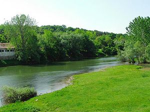
The Ogosta (Bulgarian: Огоста, Latin Augusta), is a river in Northern Bulgaria, a right tributary of the Danube. It takes it source from Vrazha Glava Peak (935 m) on the border with Serbia. The towns of Chiprovtsi, Montana and Miziya are situated on the river's banks.

The Ogosta river is 147.4 km in length and is fed by 40 tributaries in a watershed of 3157 square kilometres. Along the river's length there are 14 irrigation systems, 8 hydropower plants and 13 dams.

Although the river is used for domestic consumption it does suffer from pollution from agriculture and factories along its banks.

The main source of income aided by the river is by farmers who breed livestock and use the water to water their livestock and grow vegetation for the livestock to eat.

Honour

Ogosta Point on Livingston Island in the South Shetland Islands, Antarctica is named after Ogosta.

Coordinates: 43°45′N 23°51′E / 43.75°N 23.85°E / 43.75; 23.85


Wikimedia Foundation. 2010.

Игры ⚽ Нужна курсовая?

Look at other dictionaries:

  • Ogosta — 43°37′50″N 23°18′30″E / 43.63056, 23.30833 …   Wikipédia en Français

  • Ogosta — Sp Ogostà Ap Огоста/Ogosta L u. Š Bulgarijoje …   Pasaulio vietovardžiai. Internetinė duomenų bazė

  • Ogosta Stadium — Full name Ogosta Stadium Location Montana, Bulgaria Coordinates …   Wikipedia

  • Ogosta Reservoir — Ogosta lake Язовир Огоста Location Montana Coordinates …   Wikipedia

  • Ogosta Apartments — (София,Болгария) Категория отеля: Адрес: Ogosta Str. 5, 1124 София, Болгария …   Каталог отелей

  • Ogosta lake — Infobox lake lake name = Ogosta lake Язовир Огоста image lake = Ogosta dam near Borovtsi.jpg caption lake = image bathymetry = caption bathymetry= location = Montana coords = coord|43|22|31|N|23|10|56|E|region:BG YY… …   Wikipedia

  • Ogosta Point — Location of Rozhen Peninsula on Livingston Island in the South Shetland Islands …   Wikipedia

  • Koslodui — Kosloduj (Козлодуй) Hilfe zu Wappen …   Deutsch Wikipedia

  • Kosloduj — (Козлодуй) Hilfe zu Wappen …   Deutsch Wikipedia

  • Chiprovtsi — Coordinates: 43°23′N 22°53′E / 43.383°N 22.883°E / 43.383; 22.883 …   Wikipedia

Share the article and excerpts

Direct link
Do a right-click on the link above
and select “Copy Link”