- Temescal Creek
Geobox River
name = Temescal Creek
category = Creek
native_name =
other_name =
other_name1 =
image_size = 200px
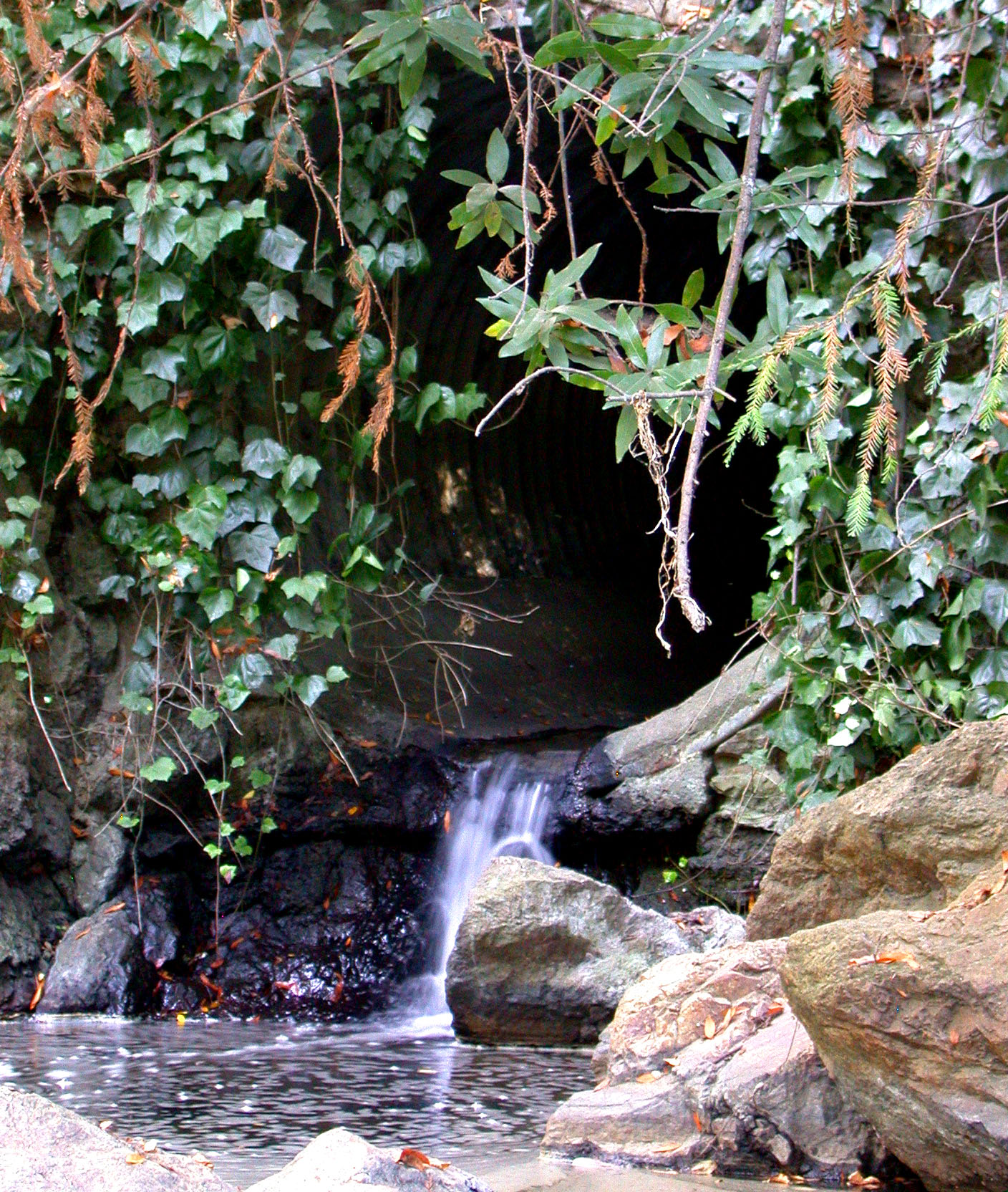
image_caption = Temescal Creek as it comes aboveground at Temescal Regional Park
etymology =
country = USA
state =California
region_type = Counties
region =Alameda County
city = Oakland
source_name =
source_location = Montclair District
source_region = Alameda County
source_state = California
source_elevation_imperial =
source_length_imperial =
source_lat_d = 37
source_lat_m = 50
source_lat_s = 34
source_lat_NS = N
source_long_d = 122
source_long_m = 12
source_long_s = 09
source_long_EW = W
source_coordinates_note = cite web| last = Geographic Names Information System | first =United States Geological Survey | date =January 19 ,1981 | url = Gnis3|236092| title = "Geographic Names Information System Feature Detail Report: Temescal Creek"| accessdate =2007-03-28]
source1_name = Claremont Creek
source1_location = near Grizzly Park Boulevard| source1_ location =| source1_region =
source1_elevation_imperial =
source1_lat_d = 37 | source1_lat_m = 52 | source1_lat_s = 08 | source1_lat_NS = N
source1_long_d = 122 | source1_long_m = 13 | source1_long_s = 01 | source1_long_EW = W
source1_coordinates_note = cite web| last = Geographic Names Information System | first =United States Geological Survey | date =January 19 ,1981 | url = Gnis3|230277| title = "Geographic Names Information System Feature Detail Report: Claremont Creek"| accessdate =2007-03-28]
mouth_name = culvert towardSan Francisco Bay
mouth_location = Oakland
mouth_region = Alameda County
mouth_state = California
mouth_country =
mouth_note =
mouth_lat_d = 37
mouth_lat_m = 50
mouth_lat_s = 2
mouth_lat_NS = N
mouth_long_d = 122
mouth_long_m = 17
mouth_long_s = 42
mouth_long_EW = W
mouth_coordinates_note = [ [http://www.acme.com/jef/creeks/temescal/ Temescal Creek] , Berkeley Creek]
mouth_elevation_imperial =
mouth_elevation_note =
length_imperial =
length_round =
length_note =
watershed_imperial =
watershed_round =
watershed_note =Temescal Creek is one of the principal watercourses in the city of
Oakland, California ,United States .The word "temescal" derives from the word "temescalli", which means "sweat house" in the
Nahuatl language of theMexica ("Aztec") people ofMexico . The name was given to the creek when it became part of the Peralta's Rancho San Antonio. It is surmised that the Peraltas or perhaps one of their ranch hands (vaquero s) had seen local indigenous (Ohlone ) structures along the creek similar to those in other parts ofNew Spain which were called "temescalli".Two forks begin in the
Berkeley Hills in the northeastern section of Oakland (sometimes referred to as the "Oakland Hills"), part of thePacific Coast Ranges , coming together in the Temescal district of Oakland, then flowing westerly across Oakland and Emeryville toSan Francisco Bay .The north fork of Temescal Creek was re-named "Harwood's Creek" in the 19th century after the owner of land in the upper stretches of the north fork. It was re-named yet again "Claremont Creek" in the early 20th century after a residential development in the same vicinity, today's Claremont district.
The south fork begins in the northern section of Oakland's Montclair district, flowing southwest out of a canyon in the hills, then turning abruptly northwestward in the linear valley formed by the Hayward Fault. It then flows into
Lake Temescal , a naturalsag pond which was dammed in the 19th century to increase its capacity for use as a reservoir. Lake Temescal is now a public park.The creek continues out of Lake Temescal, curving westerly around the end of the
shutter ridge in the Rockridge district of Oakland, then flowing almost in a line toward the Bay.Mouth area
Temescal Creek is a
perennial stream , and as such, was highly valued by earlysettler s. At its mouth, the indigenousOhlone people (Chochen/Huichin band), and their predecessors, built up a largeshellmound on the site of today's Emeryville, the largest and most studied shellmound on the shoreline of San Francisco Bay.When the area was part of the Peralta's Rancho San Antonio, the site near the shellmound was one of the principal landings for the ranch where their cattle and hides were loaded for shipping. Cattle and other livestock were slaughtered in this vicinity right up through the early 20th century for various meatpacking plants in an area which became known as "Butchertown".
It is believed that Temescal Creek once supported a population of
rainbow trout , though urbanization and the damming at Lake Temescal have led to their decline. [Leidy, R.A., G.S. Becker, B.N. Harvey. 2005. [http://www.cemar.org/pdf/alameda.pdf Historical distribution and current status of steelhead/rainbow trout (Oncorhynchusmykiss) in streams of the San Francisco Estuary, California] . Center for Ecosystem Management and Restoration, Oakland, CA.] Archeological evidence indicates thatcoho salmon were also likely found at one time in the creek. [Leidy, R.A., G. Becker, and B.N. Harvey. 2005. [http://www.cemar.org/pdf/coho.pdf Historical Status of Coho Salmon in Streams if the Urbanized San Francisco Estuary, California] . California Fish and Game 9(14): 1-36.]Today, the creek is mostly underground in
culvert s in the flatlands, but many stretches are open above Lake Temescal. In 2000, a segment of the creek below the tracks of theUnion Pacific Railroad in Emeryville became accessible to the public after the demolition of one of the buildings of the historicSherwin-Williams paint factory in early 2000. Temescal Creek now flows in an open culvert through the 2002 Bay Street Mall development. This is just about the spot where theEmeryville Shellmound once stood. A small informational park commemorating the creek and theOhlone presence at the site is situated here.At Shellmound Street, which runs approximately along the original Bay shoreline, the creek returns to a culvert which takes it to
San Francisco Bay . This straight course, however, is a later imposition - the original course of the creek bent south and entered the Bay near the northern edge of theIKEA property. Temescal Creek near the mouth area is channelized with concrete linings. The mouth of Temescal Creek at the discharge toSan Francisco Bay is fully tidal and consists ofmudflat s andmarsh land. Historically both banks of Temescal Creek in the lower area of Emeryville were part of the San Francisco Bay tidalfloodplain and were extensively filled from about 1900 through the 1970s. Fill included slag, soil and other inert materials originating from theJudson Steel plant. [Earth Metrics Inc, "Environmental Site Assessment, Chiron Site, Emeryville, California", Report no. 7911, March, 1989] The Judson plant occupied much of the lower reach banks in Emeryville; Judson used this reach for metal recycling/recovery. Foundations remained of a shear, tin baler, scale, and conveyor as late as 1990 when the lower banks were renamed the "Chiron " site and re-developed.ee also
*
Sausal Creek
*Codornices Creek
*Schoolhouse Creek
*Strawberry Creek References
* "Durham's Place-Names of the San Francisco Bay Area", by David L. Durham, Published 2000 by Quill Driver Books, ISBN 1884995357
External links
* [http://www.thewatershedproject.org/temescalcreek/ Friends of Temescal Creek]
Wikimedia Foundation. 2010.