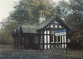
- Dunrobin Castle railway station
-
Dunrobin Castle 

The station photographed in 1989 Location Place Dunrobin Castle Local authority Highland Coordinates 57°59′10″N 3°56′56″W / 57.986°N 3.949°WCoordinates: 57°59′10″N 3°56′56″W / 57.986°N 3.949°W Operations Station code DNO Managed by First ScotRail Number of platforms 1 Live arrivals/departures and station information
from National Rail EnquiriesAnnual rail passenger usage 2004/05 * 299 2005/06 *  357
3572006/07 *  357
3572007/08 *  423
4232008/09 *  572
5722009/10 *  488
488History Original company Duke of Sutherland's Railway 1 November 1870[1] Opened 19 June 1871[1] Closed ? Reopened 29 January 1965[1] Closed 30 June 1985[1] Reopened National Rail - UK railway stations A B C D E F G H I J K L M N O P Q R S T U V W X Y Z * Annual passenger usage based on sales of tickets in stated financial year(s) which end or originate at Dunrobin Castle from Office of Rail Regulation statistics. Please note: methodology may vary year on year. Dunrobin Castle railway station is a railway station serving Dunrobin Castle in the Highland council area of Scotland. The station is on the Far North Line. Many timetables list it as being a "summer only" station, closing in late September.
It was originally a private station for the castle, the seat of the Duke of Sutherland. The Arts and Crafts style waiting room was constructed in 1902, and is a category B listed building.[2] Dunrobin Castle is situated near the village of Golspie.
References
- ^ a b c d Butt 1995, p. 86.
- ^ "Dunrobin Castle Station Waiting Room, Listed Building Report". Historic Scotland. http://hsewsf.sedsh.gov.uk/hslive/hsstart?P_HBNUM=7054. Retrieved 2009-09-15.
Sources
- Butt, R. V. J. (1995). The Directory of Railway Stations: details every public and private passenger station, halt, platform and stopping place, past and present (1st ed.). Sparkford: Patrick Stephens Ltd. ISBN 1-8526-0508-1. OCLC 60251199.
External links
- Train times and station information for Dunrobin Castle railway station from National Rail
Preceding station  National Rail
Following station Golspie First ScotRail
Far North LineBrora Categories:- Scotland railway station stubs
- Railway stations in Highland (council area)
- Railway stations opened in 1874
- Railway stations closed in 1965
- Railway stations opened in 1985
- Former Highland Railway stations
- Beeching closures in Scotland
- Railway stations served by First ScotRail
- Category B listed buildings in Scotland
- Listed buildings in Highland (council area)
- Listed railway stations in Scotland
Wikimedia Foundation. 2010.
