- Aogashima, Tokyo
Japanese city
Name = Aogashima Village
JapaneseName = 青ヶ島村
Prefecture =Tokyo Metropolis
Region = Kantō
Area_km2 = 5.98
Population = 220
PopDate =July 1 ,2008
Density_km2 = 33.8
Coords =
LatitudeDegrees = 32
LatitudeMinutes = 27
LatitudeSeconds = 48
LongtitudeDegrees = 139
LongtitudeMinutes = 45
LongtitudeSeconds = 59
Postal code =
Area code =
Mayor =
Tree = None
Flower = None
Bird = None
Symbol
SymbolDescription = Flag
CityHallPostalCode = 100-1701
CityHallAddress = Aogashima-mura, Mubanchi
CityHallPhone = 04996-9-0111
CityHallLink = [http://www.vill.aogashima.tokyo.jp/index.php Aogashima Village]
City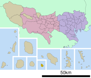
Elevation =nihongo|Aogashima|青ヶ島村|Aogashima-mura is a village located inTokyo ,Japan .As of
April 1 ,2008 , the village, which covers the island ofAogashima , had a population of 198 people and an area of 5.98km². Aogashima is the least populous municipality in the whole of Japan. It is not located in a district, but is part of theHachijō Subprefecture .Geography
Located on the isolated island of Aogashima, it is 358.4km south of mainland Tokyo. It is part of the
Izu Islands , and is 71.4km apart from the closest isle ofHachijōjima .Education
Because Aogashima has a small population, there is one school that is available to elementary and the junior high school students. nihongo| [http://www6.ocn.ne.jp/~aogasima/ Aogashima Elementary-Junior High School] |青ヶ島村立青ヶ島小中学校 serves student populations.
Gallery
ee also
References
External links
* [http://www.vill.aogashima.tokyo.jp/index.php Aogashima Official Site]
Wikimedia Foundation. 2010.