Papaloapan River

Papaloapan River

Infobox River
river_name = Papaloapan River


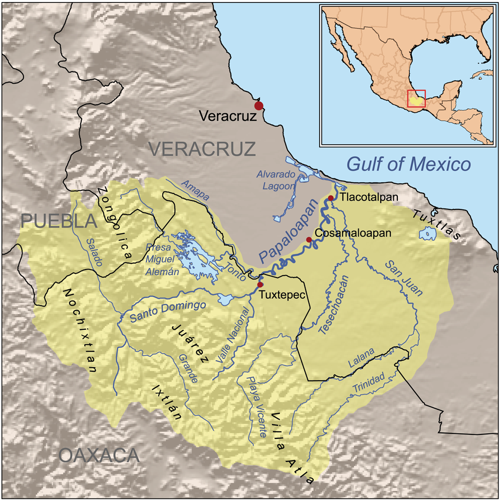
caption = Map of the Papaloapan River drainage basin
origin = Northeast Oaxaca, in Tuxtepec
mouth = Gulf of Mexico, Alvarado municipality, Veracruz
basin_countries = Mexico
length = convert|900|km|mi|0|abbr=on
elevation = convert|3700|m|ft|-1|abbr=on at source to sea level at mouth
discharge =
watershed = convert|46560|km2|sqmi|0|abbr=on
The Papaloapan River ( _es. Río Papaloapan) is one of the main rivers of the Mexican state of Veracruz. Its name is derived from the Nahuatl "papalotl" ("butterfly") and "apan" ("river").

The Papaloapan rises in the Sierra Madre Oriental on the border between the states of Veracruz and Oaxaca. Its course takes it 122 km in a northeasterly direction before draining into Alvarado lagoon.

The cities of San Juan Bautista Tuxtepec (Oaxaca) and Tlacotalpan (Veracruz) are situated on the banks of the Papaloapan.


Wikimedia Foundation. 2010.

Игры ⚽ Поможем сделать НИР

Look at other dictionaries:

  • Papaloapan River — ▪ river, Mexico Spanish  Río Papaloapan        river in Veracruz state, southeastern Mexico. It is formed by the junction of several rivers in Oaxaca state near the Veracruz–Oaxaca border and meanders generally northeastward for 76 miles (122 km) …   Universalium

  • Río Papaloapan — Saltar a navegación, búsqueda Para otros usos de este término, véase Papaloapan. Papaloapan Vista del río Papaloapan …   Wikipedia Español

  • Cerro de Oro Dam — Location Oaxaca, Mexico Coordinates 17°59′55″N …   Wikipedia

  • Miguel Alemán Dam — Location Oaxaca, Mexico Coordinates 18°13′59″N …   Wikipedia

  • Папалоапан — Река Папалоапан в штате Веракрус Папалоапан (исп. Río Papaloapan)  река в Центральной Америке, протекает по югу Мекс …   Википедия

  • Hotel Estancias De Sotavento Las Mariposas — (Tlacotalpan,Мексика) Категория отеля: Адрес: Miguel Z …   Каталог отелей

  • Mexico — /mek si koh /, n. 1. a republic in S North America. 97,563,374; 761,530 sq. mi. (1,972,363 sq. km). Cap.: Mexico City. 2. a state in central Mexico. 6,245,000; 8268 sq. mi. (21,415 sq. km). Cap.: Toluca. 3. Gulf of, Mexican, Golfo de México /gawl …   Universalium

  • Сан-Хуан-Баутиста-Тустепек — Город и муниципалитет Сан Хуан Баутиста Тустепек San Juan Bautista Tuxtepec Герб …   Википедия

  • Cosamaloapan, Veracruz — Cosamaloapan is a municipality located in the plains of the Sotavento zone in the central zone of the State of Veracruz, about 240 km from state capital Xalapa. It has a surface of 323.26 km2. It is located at 18°22′N 95°48′W / 18.367°N 95 …   Wikipedia

  • Tres Zapotes — is a Mesoamerican archaeological site located in the south central Gulf Lowlands of Mexico in the Papaloapan River plain. Tres Zapotes is sometimes referred to as the third major Olmec capital (after San Lorenzo Tenochtitlán and La Venta),… …   Wikipedia

Share the article and excerpts

Direct link
Do a right-click on the link above
and select “Copy Link”