- Rio Negro (Amazon)
:"For other uses see:
Rio Negro (disambiguation) "Geobox|River
name = Negro
other_name = Guainía
other_name1 =
other_name2 =
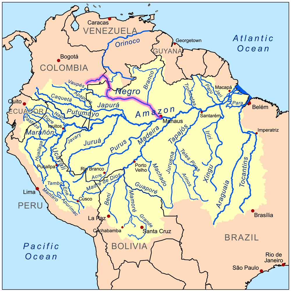
map_caption = Map showing the Rio Negro in the Amazon River basin.
country_
country = Colombia
country1 = Venezuela
country2 = Brazil
country_
length = 2230
length_round = -1
length_note = approx.
watershed = 691000
watershed_round = -3
watershed_note =
discharge_location =
discharge = 29300
discharge_round = -2
discharge_note =
discharge_max_month =
discharge_max =
discharge_min_month =
discharge_min =
discharge1_location =
discharge1 =
source =unnamed
source_location =Department of Guainía
source_region = Amazon Region of Colombia
source_country = Colombia
source_country1 =
source_elevation =
source_lat_d =
source_lat_m =
source_lat_s =
source_lat_NS =
source_long_d =
source_long_m =
source_long_s =
source_long_EW =
mouth_name = Amazon River
mouth_location =Manaus
mouth_region = Amazonas State
mouth_country = Brazil
mouth_elevation =
mouth_lat_d = 3
mouth_lat_m = 08
mouth_lat_s = 00
mouth_lat_NS = S
mouth_long_d = 59
mouth_long_m = 54
mouth_long_s = 30
mouth_long_EW = W
tributary_left =
tributary_left1 =
tributary_left2 =
tributary_right =
tributary_right1 =
tributary_right2 =

image_size =
image_caption = Sunset over the Rio Negro, a couple of kilometers upstream from ManausRio Negro (Portuguese: "Rio Negro", Spanish: "Río Negro", English: Black River) is the largest left tributary of the Amazon and the largest
blackwater river in the world. It has its sources along the watershed between theOrinoco and the Amazon basins, and also connects with the Orinoco by way of theCasiquiare canal . In Colombia, where the sources are located, it is called the Guainía River. Its main affluent is the Vaupés, which disputes with the headwaters of the Guaviare branch of theOrinoco , the drainage of the eastern slope of theAndes ofColombia . The Rio Negro flows into the Rio Solimões to form the Amazon River belowManaus ,Brazil .Rio Negro is navigable for convert|450|mi|km|-1 above its mouth for convert|4|ft|m|0 of water in the dry season, but it has many sandbanks and minor difficulties.
In the
wet season , it floods the country far and wide, sometimes to a breadth of convert|20|mi|km|0, for long distances, and for convert|400|mi|km|-1 up. During this time, from April until October, it is a succession of lagoons, full of long islands and intricate channels as far asSanta Isabel do Rio Negro . The foothills of the Andes begin just before reaching theVaupés River . At this point, the Negro narrows and is filled with many large rocks over which it violently flows in cataracts, rapids and whirlpools. Despite the impediments, canoes and motor launches ascend pastSão Gabriel da Cachoeira to theAndes .While the name "Rio Negro" means "Black River", its waters aren't exactly black; they are similar in color to strong
tea . The dark color comes from humic acid from incomplete breakdown of phenol-containing vegetation from sandy clearings. The river's name arises from the fact that it looks black from afar.Much has been written on the productivity of the Rio Negro and other blackwater rivers. The older idea that these are "hunger rivers" is giving way, with new research, to the recognition that the Rio Negro, for example, supports a large fishing industry and has numerous turtle beaches. If the Negro was empty of Indians during the 17th century, introduced exotic diseases and warfare are more likely causes than low river productivity.
References
* Goulding, M., Carvalho, M. L., & Ferreira, E. J. G. (1988). "Rio Negro, rich life in poor water : Amazonian diversity and foodchain ecology as seen through fish communities". The Hague: SPB Academic Publishing. ISBN 9051030169
* Saint-Paul, U., Berger, U., Zuanon, J., Villacorta Correa, M. A., García, M., Fabré, N. N., et al. (2000). Fish communities in central Amazonian white- and blackwater floodplains. "Environmental Biology of Fishes, 57"(3), 235-250.
* Sioli, H. (1955). Beiträge zur regionalen Limnologie des Amazonasgebietes. III. Über einige Gewässer des oberen Rio Negro-Gebietes. "Arch. Hydrobiol., 50"(1), 1-32.
* Wallace, A. R. (1853). "A narrative of travels on the Amazon and Rio Negro, with an account of the native tribes, and observations on the climate, geology, and natural history of the Amazon Valley". London: Reeve.
* Wright, R. (2005). "História indígena e do indigenismo no Alto Rio Negro". São Paulo, Brazil: UNICAMP & Instituto Socioambiental. ISBN 8575910426

Wikimedia Foundation. 2010.