- Boulevard de l'Hôpital
Paris_streetbox
arr_num=13e
paris_
x=147
y=129
streetname=Boulevard de l'Hôpital
arr1=XIIIe
quarter=
quart1=Pitié-Salpêtrière
begins=Place Valhubert
ends=Place d'Italie
length=1,395
width=43
creation=1760
denomination=August 9, 1760
area_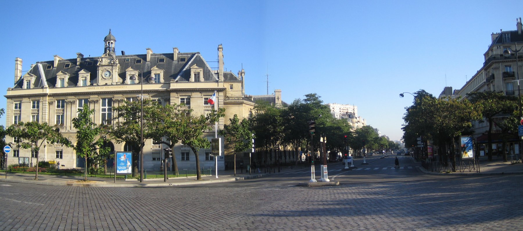
caption=Town hall of the XIII arrondissement and the boulevard de l'HôpitalThe boulevard de l'Hôpital is a tree-lined boulevard of Paris's 13th arrondissement, which also briefly borders on the 5th arrondissement.
It runs a distance of 1,395 meters, from the Place Valhubert at the
pont d'Austerlitz , by thegare d'Austerlitz , rising in a gentle slope towards its end at theplace d'Italie - the town hall of the arrondissement being located at their intersection. Along the way, it serves theJardin des Plantes and the Hôpital de la Pitié-Salpêtrière from which it derives its name. In front of the hospital, is a statue of doctorPhilippe Pinel .The boulevard is an important traffic axis. Bordered by public and teaching establishments such as the general police station of the arrondissement and the [http://fr.wikipedia.org/wiki/%C3%89cole_nationale_sup%C3%A9rieure_d%27arts_et_m%C3%A9tiers École nationale supérieure d'arts et métiers (in French)] in addition to those above, it has relatively little commercial and leisure activity excepting the shops and restaurants close to the gare d'Austerlitz.
The métro Line 5 runs through the Austerlitz viaduct, along the boulevard which has four stations:
*Gare d'Austerlitz (at its northmost end)
* Saint Marcel (opposite Hôpital de la Pitié-Salpêtrière)
* Campo Formio
* Place d'Italie (at its southmost end)History
The boulevard is one of the "Boulevards du midi" of
Louis XIV , constructed to supplement the band of boulevards already completed on the right bank of theSeine . However, the work advanced very slowly and the boulevard only finally opened in 1760. It was then the start of the road toFontainebleau , which followed the course of the presentavenue d'Italie .In the projects for the restoration of Paris in the post-war period (the 1959 town-planning directive), it was intended that the boulevard de l'Hôpital be integrated into an expressway crossing Paris from south to north, which would have joined the
boulevard Richard-Lenoir on the right bank. However, this plan was never implemented, so the layout of the boulevard has scarcely changed from the original.Composition
The odd-numbered buildings are on the Gare d'Austerlitz/Pitié-Salpêtrière (eastern) side of the boulevard and the even-numbered buildings on the opposite (western) side.
Odd numbers
* n° 1-27 : Gare d'Austerlitz
** n° 7 : Houses "L'Association pour l'histoire des chemins de fer en France" (Association for the history of railways in France.)
* n° 47-97 : Hôpital de la Pitié-Salpêtrière
** n° 47 : "Chapelle de la Salpêtrière" (Hospital Chapel), masterpiece ofLibéral Bruant architect ofles Invalides , built around 1675, on the model of a Greek cross. It has 4 central chapels each capable of holding a congregation of some 1,000 people. It has a central octagonal cupola illuminated by picture windows in circular arcs.
*** Also houses ARTC "Association pour la Recherche sur les Tumeurs Cérébrales" (Association for Research on Cerebral Tumours).
*** Occasionally houses art exhibitions. The Bombay-born British sculptor,Anish Kapoor has exhibited here.
* n° 91 and 105 : [http://www.chups.jussieu.fr/infofac/presentethistorique.htm Pitié-Salpêtrière Faculty of Medicine (in French)] .
* n° 103/105/105B : Centre Hospitalier Universitaire.
* n° 149-155 : [http://fr.wikipedia.org/wiki/%C3%89cole_nationale_sup%C3%A9rieure_d%27arts_et_m%C3%A9tiers École nationale supérieure d'arts et métiers, ENSAM (in French)]
** n° 151 :Underground Amphitheater of ENSAM - a reinforced concrete thin-shell structure built in 1960–1961 which has been shown at theMuseum of Modern Art , as part of the programme devoted to 20th Century Engineering. Structurae|id=s0018630|title=Underground Amphitheater of the Ecole Nationale d'Ingénieurs des Arts et Métiers.
* n° 159 : Primary School.Even numbers
* n° 50-52 : The fictional "maison Gorbeau" in Book 4 ("La masure Gorbeau ", Gorbeau's hovel) of
Victor Hugo 'sLes Misérables .
* n° 56 : AOF "Association des Optométristes de France" (Association of French Optometrists).
* n° 66 : Annex of the préfecture of police, which was captured at midnight onAugust 25 ,1958 by FLN commandos, controlled by "Mohand Ouramdane Saâdaoui" and "Mohammed Mezrara" (also known as "Hamada"). Of the four policemen guarding the building, three were killed and the fourth seriously wounded.
* n° 80 : Saint Marcel was buried in a funerary basilica destroyed at the beginning of the 19th century. The modern Roman Catholic church of [http://catholique-paris.cef.fr/diocese/paroisses/detail.php?par=13MAR Saint-Marcel (in French)] at n° 80 - 82 was built around 1960 some 500 m from the site of the basilica. It has a triangular campanile built in 1995 and underneath is the Sainte-Genevière chapel and an American oratory. It has a 1967 [http://orgue.free.fr/a13o7.html Beuchet-debierre organ (in French)] .
* n° 82 : Coptic Orthodox church of [http://en.parisinfo.com/rub5980.html&type_MM=61&OTCP_type=musee&id_entite=585&OTCP_action=detail&id_article=6449 Saint Marcel]
* n° 106-112 : Sorbonne Economics Center, [http://mse.univ-paris1.fr research centers in economics, statistics and mathematical economics (in French)]
* n° 144 : Police Commissariat for the 13th arrondissement.Trivia
#"Boulevard De L'hôpital" is the title of Track 11 of Les Créatures by the French artist Philippe Katerine (links in French).
External links
* [http://www.v1.paris.fr/CARTO/Nomenclature/4649.nom.html Official naming of Paris streets (in French)]
* [http://www.paris-expert.com/parisexpert/Plans/Paris.cfm?Lat=&Lon=&Scale=&TEC=g Map of Paris (browser plugin required)]
* [http://www.insecula.com/salle/panorama_MS02698.html Panoramic views of Boulevard de l'Hôpital (in French)]
* [http://maps.google.com/maps?q=paris,+france&ll=48.843120,2.365032&spn=0.003005,0.010274&t=h&hl=en Satellite image from Google Maps of gare d'Austerlitz]
Wikimedia Foundation. 2010.