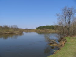
Meshchera Lowlands

Meshchera Lowlands
Vladimir Meshchera

Meshchera Lowlands (Meshchyora Lowlands), also referred to as simply "Meshchera"/"Meshchyora" (Russian: Мещёрская низменность) is a spacious lowland in the middle of the European Russia. It is named after the Finno-Ugric Meshchera tribe, which used to live there. It occupies parts of Moscow Oblast, Vladimir Oblast and Ryazan Oblast; respectively, it is spoken of Moscow, Vladimir, and Ryazan Meshcheras.

Geography

Meshchera is a plain of roughly triangular shape bounded by rivers Oka from the South, Moskva River from the Southwest, Klyazma from the North and Sudogda and Kolp/Kolpna (Колпь, Колпна) from the East. Elevation: 80–130 metres.

It is covered by mixed forests, pine forests in sandy areas, with a large number of wetlands and lakes.

Coordinates: 55°10′58″N 40°20′00″E / 55.18278°N 40.3333333°E / 55.18278; 40.3333333


Wikimedia Foundation. 2010.

Игры ⚽ Поможем решить контрольную работу

Look at other dictionaries:

  • Lowlands — or The Lowlands can refer to;Geographic regions * Scottish Lowlands, all of mainland Scotland that isn t the Highlands (see also: Central Lowlands) * Northern European Lowlands, a region of Europe between the Central Highlands and the North Sea… …   Wikipedia

  • Meshchera — The Meshchera ( ru. Мещёра, Meshchyora) were a Finno Ugric tribe which lived in the territory between the Oka River and the Klyazma river. It was a land of forests, bogs and lakes. The area is still called the Meshchera Lowlands. The name may be… …   Wikipedia

  • Volga Finns — Approximate ethno linguistic map of European Russia in the 9th century: The five Volga Finnic groups of the Merya, Mari, Muromians, Meshchera and Mordvins are shown as surrounded by the Slavs to the west, the (Finnic) Veps to the northwest, the… …   Wikipedia

  • Moscow Oblast — Московская область (Russian)   Oblast   …   Wikipedia

  • Losiny Ostrov National Park — Infobox protected area | name = Losiny Ostrov National Park iucn category = II caption = locator x = locator y = location = Russia nearest city = Moscow lat degrees = lat minutes = lat seconds = lat direction = long degrees = long minutes = long… …   Wikipedia

  • Shatursky District — ( ru. Шатурский район) is a district (raion) of Moscow Oblast, Russia. The area of the district is 2,715 km². Its administrative center is the town of Shatura. According to the population census, the population of the district in 2002 was… …   Wikipedia

  • Melenki, Vladimir Oblast — For other places with the same name, see Melenki. Coordinates: 55°20′N 41°38′E / 55.333°N 41.633°E / 55.333; 41.633 …   Wikipedia

Share the article and excerpts

Direct link
Do a right-click on the link above
and select “Copy Link”