- Gannett Glacier
Infobox_Glacier | glacier_name = Gannett Glacier
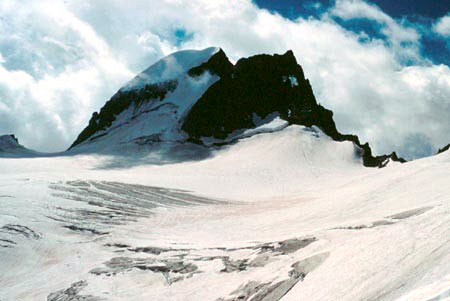
caption = Gannett Glacier on the north slope ofGannett Peak
type = Mountain glacier
location =Wyoming , U.S.
coordinates = coord|43|11|48|N|109|39|02|W|region:US_type:glacier|display=inline,title
area = convert|3.63|km2|acre|0|lk=on (in 1999)
length =
thickness =
terminus = Moraine
status = RetreatingGannett Glacier is the largest
glacier in theRocky Mountains within theUnited States . The glacier is located on the east and north slopes ofGannett Peak , the highest mountain inWyoming on the east side of theContinental Divide in theWind River Range . Gannett is but one of dozens of glaciers located in theFitzpatrick Wilderness ofShoshone National Forest . [cite web | url = http://www.topoquest.com/map.asp?z=12&n=4783025&e=609710&s=50&size=l&datum=nad83&layer=DRG25 | title = USGS Gannett Peak (WY) Topo Map | format = Map| work = | publisher = TopoQuest | accessdate = 2007-03-30]As is true with most glaciers around the world, Gannett Glacier is slowly disappearing. Photographic evidence clearly demonstrates that there has been an enormous reduction in the area of the glacier since the 1920s. The area of the glacier was estimated in 1950 to be convert|4.6|km2|acre|0 and was measured in 1999 to be convert|3.63|km2|acre|0|lk=on. Measurements taken in 1958 and again in 1983 showed a depth reduction of convert|18.6|m|ft|0|lk=on over 25 years.cite web | last = Urbigkit | first = Cat | authorlink = | coauthors = | year = | url = http://www.sublette.com/examiner/v5n23/v5n23s3.htm | title = Glaciers shrinking | format = | work = | publisher = Sublette Examiner | accessdate = 2007-03-30] A general warming pattern and a reduction in moisture is widely believed to be the reason for the glacier retreating.cite web | last = Absolon | first = Molly | authorlink = | coauthors = | year = | url = http://www.wyomingoutdoorcouncil.org/news/newsletter/docs/2003a/ | title = Vanishing Glaciers in the Wind River Range | format = | work = | publisher = Wyoming Outdoor Council | accessdate = 2007-03-30] Numerous other glaciers are located in the immediate area including six more that are within the top ten in size within the Rocky Mountains of the U.S.
In a 1989 study, both Gannett and Dinwoody glaciers were researched to determine the amount of melt water they supplied to streams. Both glaciers supply melt water which flows into Dinwoody Creek, which in turn flows into the
Wind River . The melt water was found to have contributed increasingly lower amounts to the total water supplied to Dinwoody Creek. This has been attributed to the glaciers thinning and retreating, especially since 1950, when Gannett Glacier was measured to be almost 20 percent larger than in 1999.cite web| last =Pochop| first =L.| authorlink =| coauthors =R. Marston, G. Kerr, D. Veryzer, M. Varuska and R. Jacobel| title =Glacial Icemelt in the Wind River Range, Wyoming| work = Watershed Planning and Analysis in Action Symposium Proceedings of IR Conference Watershed Mgt/IR Div/ASCE| publisher =Water Resources Data System Library| date =July 9-11, 1990| url =http://library.wrds.uwyo.edu/wrp/90-16/90-16.html| format =| doi =| accessdate = 2007-06-06 ] The impact on reduced stream flow from Gannett Glacier due to glacial retreat affects more than just the amount of water available for the local ecosystem and downstream agricultural and ranching interests. Cool water fish species including thebrook trout ,cutthroat trout andrainbow trout could see a loss of habitat and spawning areas as water temperatures rise due to less glacier ice melt.Cited references
ee also
*
List of glaciers
Wikimedia Foundation. 2010.