- Flores, El Petén
Infobox Settlement
official_name = Flores
other_name =
native_name =
nickname =
settlement_type =
motto =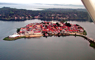
imagesize =300px
image_caption =
flag_size =
image_
seal_size =
image_shield =
shield_size =
image_blank_emblem =
blank_emblem_type =
blank_emblem_size =
mapsize =
map_caption =
mapsize1 =
map_caption1 =
image_dot_
dot_mapsize =
dot_map_caption =
dot_x = |dot_y =
pushpin_
pushpin_label_position =bottom
pushpin_map_caption =Location in Guatemala
subdivision_type = Country
subdivision_name =
subdivision_type1 = Department
subdivision_name1 = Petén
subdivision_type2 =
subdivision_name2 =
subdivision_type3 =
subdivision_name3 =
subdivision_type4 =
subdivision_name4 =
government_footnotes =
government_type =
leader_title =
leader_name =
leader_title1 =
leader_name1 =
leader_title2 =
leader_name2 =
leader_title3 =
leader_name3 =
leader_title4 =
leader_name4 =
established_title =
established_date =
established_title2 =
established_date2 =
established_title3 =
established_date3 =
area_magnitude =
unit_pref =Imperial
area_footnotes =
area_total_km2 =
area_land_km2 =
area_water_km2 =
area_total_sq_mi =
area_land_sq_mi =
area_water_sq_mi =
area_water_percent =
area_urban_km2 =
area_urban_sq_mi =
area_metro_km2 =
area_metro_sq_mi =
area_blank1_title =
area_blank1_km2 =
area_blank1_sq_mi =
population_as_of =2002
population_footnotes =
population_note =
population_total =13,700
population_density_km2 =
population_density_sq_mi =
population_metro =
population_density_metro_km2 =
population_density_metro_sq_mi =
population_urban =
population_density_urban_km2 =
population_density_urban_sq_mi =
population_blank1_title =Ethnicities
population_blank1 =
population_blank2_title =Religions
population_blank2 =
population_density_blank1_km2 =
population_density_blank1_sq_mi =
timezone =
utc_offset =
timezone_DST =
utc_offset_DST =
latd=16 |latm=54 |lats= |latNS=N
longd=89|longm=54 |longs= |longEW=W
elevation_footnotes =
elevation_m =
elevation_ft =
postal_code_type =
postal_code =
area_code =
blank_name =
blank_info =
blank1_name =
blank1_info =
website =
footnotes =Flores is the capital city of Petén department of
Guatemala . It is located at coord|16|54|N|89|54|W|. The population is 13,700 (2003 ).Flores serves as the municipal seat for the surrounding municipality, with which it shares a name (population 22,600).
The old part of the city is located on an
island onLake Peten Itza , connected to the mainland by a short causeway. On the mainland are the suburb towns of Santa Elena and San Benito.In
Pre-Columbian times, Flores was the Maya city ofTayasal .Transportation
Flores is served by the Santa Elena International Airport but commonly known as
Mundo Maya International Airport . Several International flights are served but mainly all of them stop first onGuatemala City 'sLa Aurora International Airport .Tayasal
The
Itza left theYucatán region in the13th century and built the city later known as Tayasal as their capital. They called it "Noh Petén", literally "City Island". It was also called "Tah Itzá", or Place of the Itzá.It was here, on the island of Flores on the shore of Lake Petén Itzá, that the last independent Maya state held out against the Spanish conquerors. In1541 ,Hernán Cortés came to the island, on route toHonduras , but needed to move on and did not try to conquer it.The Spanish did not manage to conquer the island until
1697 , when they marched in, attacked via boats, and destroyed it. Those who could flee did so, and many Itzá people hid in the jungle for years. From the ruins of Noh Petén arose the modern city of Flores.ee also
*
Spanish conquest of Yucatán References
External links
* on
Wikitravel

Wikimedia Foundation. 2010.