Saunderstown, Rhode Island
- Saunderstown, Rhode Island
Infobox_nrhp | name =Saunderstown Historic District
nrhp_type = hd
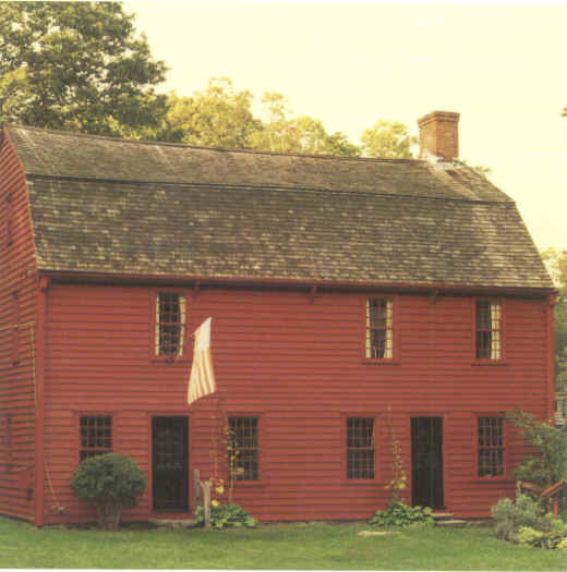
caption = The Gilbert Stuart Birthplace is located in Saunderstown.
location= North Kingstown, Rhode Island
locmapin = Rhode Island
area =
built =1856
architect= Multiple
architecture= Colonial Revival, Bungalow/Craftsman, Other
added = July 19, 1985
governing_body = Private
mpsub=North Kingstown MRA
refnum=85001647[cite web|url=http://www.nr.nps.gov/|title=National Register Information System|date=2007-01-23|work=National Register of Historic Places|publisher=National Park Service] ]Saunderstown is a small village and historic district in North Kingstown, Rhode Island, USA. It is located in Washington County.
Saunderstown is known as the birthplace of the artist Gilbert Stuart, who is best known for painting the portrait of George Washington that is portrayed on the one-dollar bill. The Gilbert Stuart Birthplace and Museum, which consists of the house in which Stuart was born, a nature trail, and a functional gristmill, is now open to the public as a museum. [http://www.epodunk.com/cgi-bin/genInfo.php?locIndex=13452 Saunderstown, Rhode Island Community Profile] Saunderstown is also the location of Casey Farm, an 18th century plantation that is now a family farm. The farm grows organic vegetables, herbs, and flowers in a Community Agriculture Program. It is operated by Historic New England. [http://www.historicnewengland.org/visit/homes/casey.htm Historic New England, Casey Farm]
Saunderstown's postal code is 02874.
References
Wikimedia Foundation.
2010.
Look at other dictionaries:
Saunderstown (Rhode Island) — Distrito histórico de Saunderstown (Saunderstown Historic District) Registro Nacional de Lugares Históricos (EE. UU.) Distrito Histórico La casa natal de … Wikipedia Español
Rhode Island Route 1A — Route 1A is a numbered state highway in Rhode Island, running 34.4 miles in five sections.RouteRoute 1A follows U.S. 1 closely through South County. It can be separated into five sections:*The first section (8.8 miles in length) begins as US 1… … Wikipedia
List of the oldest buildings in Rhode Island — See also: Oldest buildings in America This article attempts to list the oldest extant buildings surviving in the state of Rhode Island in the United States of America, including the oldest houses in Rhode Island and any other surviving structures … Wikipedia
Narragansett, Rhode Island — Town … Wikipedia
Westerly, Rhode Island — Town … Wikipedia
Jamestown, Rhode Island — Infobox Settlement official name = Jamestown, Rhode Island settlement type = Town nickname = motto = imagesize = image caption = image mapsize = 250px map caption = Location of Jamestown in Rhode Island mapsize1 = map caption1 = subdivision type … Wikipedia
Charlestown, Rhode Island — Town Location of Charlestown in Washington County, Rhode Island … Wikipedia
Matunuck, Rhode Island — Matunuck is a village in South Kingstown, Rhode Island, United States near Charlestown, Rhode Island. The village is located on a point along the southern Atlantic coast of Rhode Island off of U.S. Route 1. The village takes its name from a… … Wikipedia
Wickford, Rhode Island — Infobox nrhp | name =Wickford Historic District nrhp type = hd caption = Wickford from the air, looking east. location= North Kingstown, Rhode Island locmapin = Rhode Island area = architect= Tefft,T.A.; Sawtelle,W.C. architecture= Greek Revival … Wikipedia
North Kingstown, Rhode Island — Town The Gilbert Stuart Birthplace in North Kingstown … Wikipedia