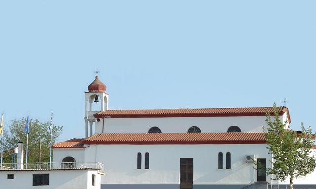
- Loutrochori, Pella
Infobox Greek Dimos
name = Loutrochori
name_local = Λουτροχώρι
periph =Central Macedonia
prefec = Pella
population = 466
population_as_of = 2001
area = 7.506
elevation =
lat_deg = 40
lat_min = 43
lon_deg = 22
lon_min = 6
postal_code = 585 00
area_code = 23810
licence = ΕΕ
mayor =
website =
caption_skyline = Church of Agii Pandes
city_
city_
districts =
municipality =Skydra
party =
since =
elevation_min = 59
elevation_max = 90Loutrochori(on) (Greek: Λουτροχώρι(οv) meaning "bath town"; formerly "Bania", Μπάνια meaning "baths"), is a village in the
Pella Prefecture , of Macedonia inGreece . According to the 2001 census, population was is 466el icon 2001 Census, National Statistical Service of Greece (ΕΣΥΕ), ( [http://www.statistics.gr/gr_tables/S1101_SAP_1_TB_DC_01_03_Y.pdf PDF 875 KB / GR-591109 02 : Λουτροχώρι (Loutrochori)] ] ), area is 3.96 square kilometers, and population density is 118 per square kilometers. The village is on a hill, giving it views over the surrounding countryside.Loutrochori is situated 25 km north to the Egnatia Highway (or GR-2, or E90). Its nearest railroad (train) stations with the OSE's SPAP line are 2.5 km east (Petrea), 5 km southeast (Episkopi) and 7 km northeast (
Skydra ). The famous spa of Loutrochori (iamatica loutra) [el icon [http://www.thermalsprings.gr/content.php?id=18. Ιαματική Πηγή Λουτροχωρίου (Δήμος Σκύδρας)] ] is situated just 0.5 km near to the lokal mountain Canber (358 m / 1,175 feet).History
Ancient era
The Loutrochori area has been a
spa from the 4th century BC under the Macedonian Kingdom.Modern era
Modern Loutrochori is a relatively new village and it was founded in the 1920s by the first
Greek refugees fromPontus , under the name "Μπάνια" ("Bania"). [el icon [http://www.freewebs.com/onoma/eap.htm „Κατάλογος των προσφυγικών συνοικισμών της Μακεδονίας σύμφωνα με τα στοιχεία της Επιτροπής Αποκαταστάσεως Προσφύγων (ΕΑΠ) έτος 1928“.] ] After thePontic Greek Genocide and theGreco-Turkish War (1919-1922) , a large number of Pontic Greek refugees arrived in the village as a result of the population exchange according to theTreaty of Lausanne . In 1926, the village name was changed to the "Λουτροχώρι" (Loutrochori). [el icon [http://www.freewebs.com/onoma/met.htm „Μετονομασίες των οικισμών της Μακεδονίας 1919 - 1971“.] ]Demographics
Big cities
Nearest Airports
References
External links
* [http://www.gtp.gr/LocPage.asp?ID=7435 Loutrochori on GTP Travel Pages (Community)]
* [http://nona.net/features/map/placedetail.739210/Loutroch%C3%B3rion/ Loutrochórion (Pélla, Macedonia, Greece)]
* [http://www.hri.org/info/maps/macedonia-5b.jpgMap of Central Macedonia. - Loutrochori NW (20)]
*el icon [http://dim-loutroch.pel.sch.gr/ Primary school of Loutrochori]
*el icon [http://nip-loutroch.pel.sch.gr/ Kindergarten of Loutrochori]
*el icon [http://epigraphy.packhum.org/inscriptions/oi?ikey=150588&caller=gis&bookid=124®ion=4 Loutrochori (epigraphy, Delacoulonche 242,24)]
*el icon [http://www.thermalsprings.gr/content.php?id=18 History and Information about the baths of Loutrochori]Geographic Location (8-way)
Centre = Loutrochori
North =Sevastiana , Rizari
Northeast = Rizo,Skydra
East = Petrea, Arseni
Southeast =Plevroma , Episkopi
South = Marina,Lefkadia
Southwest = Rodochori, Gianakochori
West =Agia Fotini , Polla Nera
Northwest =Kesariana ,Flamouria
Wikimedia Foundation. 2010.
