Mjóifjörður

Mjóifjörður
Mjóifjörður
—  Village  —
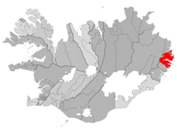
Location of the Municipality of Fjarðabyggð
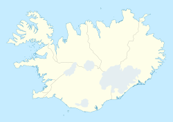
Mjóifjörður is located in Iceland
Mjóifjörður
Location in Iceland
Coordinates: 65°11′43″N 13°47′32″W / 65.19528°N 13.79222°W / 65.19528; -13.79222
Country  Iceland
Constituency[1] Map of the constituencies of Iceland Norðausturkjördæmi
Region[2] Map of the regions of Iceland Austurland
County Map of the counties of Iceland Suður-Múlasýsla
Municipality COA Fjardabyggd.png Fjarðabyggð
Population (2008)
 – Total 35
Time zone GMT (UTC+0)
Website Official website

Mjóifjörður is a village of 35 people in East Iceland, sitting on a fjord of the same name (meaning Narrow Fjord). It is part of the municipality of Fjarðabyggð.

Contents

History

In early 20th century, the village was a Norwegian whaling station. The village also hosted the Dalatangi light, Iceland's first lighthouse. It is often referred as the smallest village in the country, and one of the most diverse.

Geography

The other villages composing the municipality are: Eskifjörður (1,068 inh.), Fáskrúðsfjörður (611 inh.), Neskaupstaður (1,400 inh.),[3] Reyðarfjörður (2,238 inh.) and Stöðvarfjörður (231 inh.).[4]

References

  1. ^ Political division
  2. ^ Mainly statistical division
  3. ^ Located in the Norðfjörður
  4. ^ (Icelandic) Infos on Fjarðabyggð municipal website

External links

Media related to Mjóifjörður at Wikimedia Commons

Coordinates: 65°11′43″N 13°47′11″W / 65.19528°N 13.78639°W / 65.19528; -13.78639


Wikimedia Foundation. 2010.

Игры ⚽ Поможем сделать НИР

Look at other dictionaries:

  • Mjóifjörður — steht für: Mjóifjörður (Austurland), ein Fjord in der ostisländischen Region Austurland Mjóifjörður (Ísafjarðardjúp), ein Fjord in der westisländischen Region Vestfirðir Mjóifjörður (Kerlingarfjörður), ein Fjord im Süden der westisländischen… …   Deutsch Wikipedia

  • Mjóifjörður — Administration Pays  Islande …   Wikipédia en Français

  • Mjóifjörður (Austurland) — 65.195277777778 13.792222222222 Koordinaten: 65° 11′ 43″ N, 13° 47′ 32″ W …   Deutsch Wikipedia

  • Mjóifjörður (Kerlingarfjörður) — 65.6146 22.8403 Koordinaten: 65° 36′ 53″ N, 22° 50′ 25″ W …   Deutsch Wikipedia

  • Mjóifjörður (Ísafjarðardjúp) — 65.903611111111 22.586527777778 Koordinaten: 65° 54′ 13″ N, 22° 35′ 12″ W …   Deutsch Wikipedia

  • Mjoifjördur — Mjóifjörður steht für: Mjóifjörður (Austurland), ein Fjord in der ostisländischen Region Austurland Mjóifjörður (Ísafjarðardjúp), ein Fjord in der westisländischen Region Vestfirðir Mjóifjörður (Kerlingarfjörður), ein Fjord im Süden der… …   Deutsch Wikipedia

  • Fjarðabyggð — Basisdaten Staat: Island Region: Austurland …   Deutsch Wikipedia

  • Sólbrekka Holiday Homes — (Mjóifjörður Island,Исландия) Категория отеля: Адрес: Brekka, 715 Mjóifjörð …   Каталог отелей

  • Sólbrekka Guesthouse — (Mjóifjörður Island,Исландия) Категория отеля: Адрес: Brekka, 715 Mjóifjörður …   Каталог отелей

  • Austfirdir — Austfirðir oder deutsch Ostfjorde werden die Fjorde und Buchten an der Ostküste Islands genannt. Von Norden nach Süden: Berg Glettingur, als nördliche Grenze Húsavík, mit dem gleichnamigen, verlassenen Ort Loðmundarfjörður Seyðisfjörður, mit dem… …   Deutsch Wikipedia

Share the article and excerpts

Direct link
Do a right-click on the link above
and select “Copy Link”