- Ravine Bluffs Development
-
Ravine Bluffs Development Bridge (Sylvan Road Bridge)
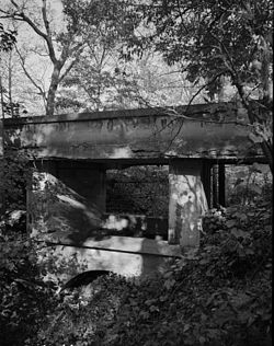

Location: Glencoe, Illinois Coordinates: 42°8′40″N 87°45′48″W / 42.14444°N 87.76333°WCoordinates: 42°8′40″N 87°45′48″W / 42.14444°N 87.76333°W Built: 1915, rebuilt 1985 Architect: Frank Lloyd Wright Architectural style: Prairie School Governing body: Private NRHP Reference#: 78001137[1] Added to NRHP: June 23, 1978 The Ravine Bluffs Development was commissioned in 1915 by Frank Lloyd Wright's attorney, Sherman Booth Jr.. It is located in Glencoe, Illinois. Six houses, three poured concrete sculptures, and one bridge were built. Five of the houses were for rent when built. All 5 rental houses share the same basic floor plan as "A Fireproof House for $5000".[2]
Client's home:
- Sherman M. Booth House
Rentals:
- Charles R. Perry House
- Hollis R. Root House
- William F. Kier House
- Lute F. and Daniel Kissam House
- William F. Ross House - differs in design from the other 4 rentals, has fireplace to the side - threatened with demolition.
Bridge
The Ravine Bluffs Development Bridge, also known as the Sylvan Road Bridge, was a bridge designed by Frank Lloyd Wright and located at the northeastern entrance of the Development. It crosses over the ravine from which the project gets its name. In the 1980s, the bridge was rebuilt. It was Wright's only bridge.
References
- ^ "National Register of Historical Places - ILLINOIS - Cook County". National Park Service. http://www.nationalregisterofhistoricplaces.com/il/Cook/state9.html.
- ^ "The Village Architecture | Village of Glencoe". Village of Glencoe. http://www.villageofglencoe.org/about/history/architecture.aspx. Retrieved 5 July 2010.
- Storrer, William Allin. The Frank Lloyd Wright Companion. University Of Chicago Press, 2006, ISBN 0226776212 (S.185-192)
External links
- Ravine Bluffs Development Markers and Bridge on dgunning.org
- Ravine Bluffs Development Bridge, Spanning ravine at Sylvan Road, Glencoe, Cook County, IL
- Ravine Bluffs Development at the archINFORM database
- Ravine Bluffs Development Corner Markers (1915), Glencoe, Illinois. Color photographs.
- Ravine Bluffs Markers and Bridge on appraisercitywide.com
- Booth House on dgunning.org
- "Sherman Booth House" Waymark
- Sherman Booth House on peterbeers.net
- Booth House on appraisercitywide.com
- Kier House on dgunning.org
- "Kier House AKA Ellis House" Waymark
- Kier House on appraisercitywide.com
- Kissam House on dgunning.org
- "Kissam House" Waymark
- Kissam House on appraisercitywide.com
- Perry House on dgunning.org
- "Perry House" Waymark
- Perry House on appraisercitywide.com
- Root House on dgunning.org
- "Root House AKA Gilfillan House" Waymark
- Root House on peterbeers.net
- Root House on appraisercitywide.com
- Ross House on dgunning.org
- William F. Ross House on landmarks.org
- "Ross House AKA Finch House" Waymark
- A Chicago Suburb Could Lose a Wright
- Ross House on appraisercitywide.com
Categories:- Frank Lloyd Wright buildings
- Glencoe, Illinois
- Houses on the National Register of Historic Places in Illinois
- National Register of Historic Places in Cook County, Illinois
- Houses in Cook County, Illinois
- Illinois building and structure stubs
- Illinois Registered Historic Place stubs


Wikimedia Foundation. 2010.