- Mira River (Nova Scotia)
-
The Mira River is a Canadian river located in southeastern Cape Breton Island, Nova Scotia.
With a meander length of approximately 55 km (34 mi) , the Mira has a very slow flow rate. The river's source is traced to a series of lakes clustered around Victoria Bridge near the boundary with Richmond County. Flowing past the communities of Marion Bridge and Albert Bridge, the river discharges through the "Mira Gut" at the community of the same name into the Mira Bay. The river occupies a trench arching from southwest to northeast across the southern part of Cape Breton County; much of the eastern part of the river is a tidal estuary, with noticeable tides extending beyond Albert Bridge approximately 10 km (6.2 mi) upstream of the Gut.
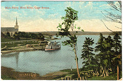 The Mira Ferry once served on the Mira River. The Albert Bridge can be seen in the background, although that span has since been replaced.
The river's width and calm waters make it ideal for pleasure boating and other recreational activities; numerous cottages line its banks. Several campgrounds and parks, along with the Mira Boat Club at Albert Bridge make the Mira River an important vacation destination in the Cape Breton Regional Municipality. Popular swimming spots include Marion Bridge, Mira Gut Beach, Sanagree Island, Mira Water Park, and Albert Bridge.
 Mira River in Nova Scotia
The Mira region is also home to the Two Rivers Wildlife Park.
The Mira River was the inspiration for local songwriter Allister MacGillivray's Song for the Mira. Over the years, it has become a renowned folk song, that has been recorded by many artists and translated into several different languages.
The mouth of the river, which drains into Mira Gut, is spanned by a bridge with a revolving middle span. This bridge, along with Albert Bridge, have been known to be used as diving boards by youths seeking adventure. The activity has not been as prevalent in recent years due to public fears of injury and liability, and to threats made by the Cape Breton Regional Police of fines or jail time for jumpers.[1] The Gut bridge was used due to the high currents experienced at mid tide. Albert Bridge was used due to its height above water and the deep pool situated below the northwestern end of the bridge.
References
Coordinates: 45°58′23.9″N 60°13′58.5″W / 45.973306°N 60.232917°W
Categories:- Geography of the Cape Breton Regional Municipality
- Rivers of Nova Scotia
- Cape Breton County, Nova Scotia geography stubs


Wikimedia Foundation. 2010.