- Tatoosh Island, Washington
Infobox_nrhp | name =Tatoosh Island
nrhp_type =
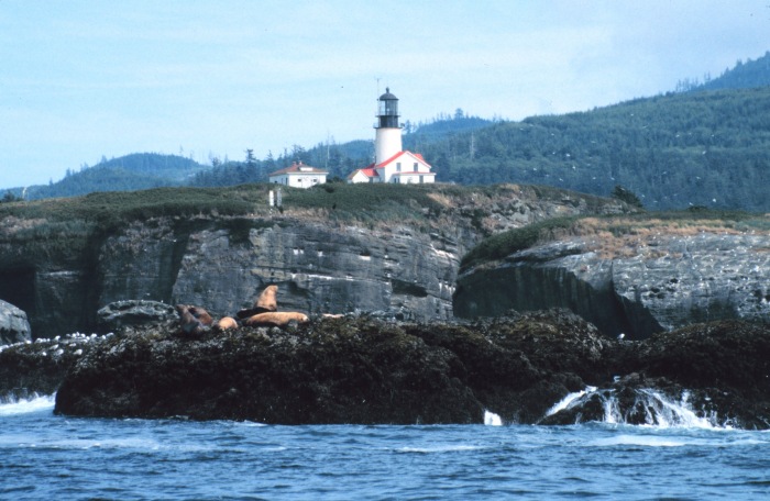
caption = Tatoosh Lighthouse from offshore
location=Olympic Peninsula ,Washington
area =
built =1857
architect= US Coast Guard
architecture= No Style Listed
added =March 16 ,1972
governing_body = COAST GUARD
refnum=72001267 cite web|url=http://www.nr.nps.gov/|title=National Register Information System|date=2007-01-23|work=National Register of Historic Places|publisher=National Park Service]Tatoosh Island is an island about a half mile off Cape Flattery on the
Olympic Peninsula inWashington . In reality there is a small group of islands, of which Tatoosh is the largest. The islands are part of theMakah Reservation , and a part of Clallam County. The total land area of the island group is 159,807 square meters (39.489acre s). There is no resident population on the islands.The island's name comes from the a Makah chief known as Tatoosh (also Tatooche or Tetacus). [ [http://www.historylink.org/essays/output.cfm?file_id=5703 Cape Flattery Light on Tatoosh Island begins operating on December 28, 1857] , HistoryLink.org]
The island has been home since
December 28 ,1857 to alighthouse which overlooks the entrance to theStrait of Juan de Fuca .Notes
References
* [http://factfinder.census.gov/servlet/DTTable?_bm=y&-context=dt&-ds_name=DEC_2000_SF1_U&-mt_name=DEC_2000_SF1_U_P001&-CONTEXT=dt&-tree_id=4001&-transpose=N&-redoLog=true&-all_geo_types=N&-_caller=geoselect&-geo_id=100$10000US530099801002046&-geo_id=100$10000US530099801002047&-search_results=100$10000US530099801001066&-format=&-_lang=en&-show_geoid=Y Tatoosh Island group: Blocks 2046 and 2047, Census Tract 9801, Clallam County, Washington] United States Census Bureau
External links
* [http://memory.loc.gov/cgi-bin/query/S?ammem/aipn:@FIELD(SUBJ+@od1(+united+states++washington++state+++tatoosh+island+)) Photos and other items about Tatoosh Island] from the
Library of Congress
* [http://content.lib.washington.edu/cgi-bin/htmldoc.exe?CISOROOT=/lctext&CISOPTR=1483 History of Tatoosh Island] from theUniversity of Washington Libraries Digital Collections website
* [http://www.ndbc.noaa.gov/station_page.php?station=ttiw1 Tatoosh Island Lighthouse] from theNational Data Buoy Center of the NOAA, with "sector pictures"
* [http://www.makah.com/neahbaymap.htm Maps including Tatoosh Island] , from the officialMakah website
* [http://www.experiencewashington.com/byways/BywayPoi.aspx?bwid=20&poi=55 Cape Flattery Tribal Scenic Byway] from theWashington State Tourism website
* [http://www.naturalmoment.com/lighthouses/Tatoosh-Light-2.html Photos of Cape Flattery Lighthouse and Helipad] , from a commercial photographer's website
* [http://www.lighthousefriends.com/light.asp?ID=120 Cape Flattery Lighthouse]
* [http://content.lib.washington.edu/cmpweb/exhibits/makah/index.html University of Washington Libraries Digital Collections – Makah Cultural and Research Center Online Museum Exhibit)] History and culture of the Makah tribe; includes images from Tatoosh Island.
* Video interview with ecologists Cathy Pfister and J. Timothy Wooton [http://research.uchicago.edu/highlights/item.php?id=8 Survival and Diversity on Tatoosh Island]
Wikimedia Foundation. 2010.