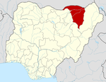
- Nguru, Nigeria
-
Nguru — LGA — Location in Nigeria Coordinates: 13°01′N 10°21′E / 13.017°N 10.35°ECoordinates: 13°01′N 10°21′E / 13.017°N 10.35°E Country  Nigeria
State Yobe State Area – Total 916 km2 (353.7 sq mi) Population (2006 census) – Total 150,632 Time zone WAT (UTC+1) 3-digit postal code prefix 630 ISO 3166 code NG.YO.NG Nguru (or N'Gourou) is a Local Government Area in Yobe State, Nigeria. Its headquarters are in the town of Nguru near the Hadejia River at 12°52′45″N 10°27′09″E / 12.87917°N 10.4525°E.
It has an area of 916 km² and a population of 150,632 at the 2006 census.
The postal code of the area is 630.[1]
The town probably dates from around the 15th century. There is a variety of landscape types in the area, including the protected Hadejia-Nguru wetlands of Nguru Lake, and the "Sand Dunes", a semi-desert area.
Transport
Nguru is the terminus of the Western Railway of Nigeria.
References
- ^ "Post Offices- with map of LGA". NIPOST. http://www.nipost.gov.ng/PostCode.aspx. Retrieved 2009-10-20.
 Yobe State
LGAs  Categories:
- Populated places in Yobe State
- Nigeria geography stubs
Wikimedia Foundation. 2010.

