- Gjerstad
Infobox_Kommune
name = Gjerstad
idnumber = 0911
county = Aust-Agder
landscape = Sørlandet
capital = Gjerstad
demonym = Gjersdøl
Gjersdøling
language = Neutral
munwebpage = www.gjerstad.kommune.no
governor = Rune Hagestrand(H)
governor_as_of = 2007
arearank = 263
area = 322
arealand = 308
areapercent = 0.10
population_as_of = 2004
populationrank = 298
population = 2,513
populationpercent = 0.06
populationdensity = 8
populationincrease = -0.6
lat_deg = 58 | lat_min = 53 | lat_sec = 33 | lon_deg = 8 | lon_min = 57 | lon_sec = 24
utm_zone = 32V | utm_northing = 6528095 | utm_easting = 0497503 | geo_cat = adm2ndGjerstad is a municipality in the county of
Aust-Agder ,Norway . The parish of "Gjerrestad" was established as a municipality on 1 January 1838 (seeformannskapsdistrikt ).General information
Name
The municipality (originally the
parish ) is named after the old "Gjerstad" farm (Old Norse : "Geirreksstaðir"), since the first church was built there. The first element is thegenitive case of the male name "Geirrekr" and the last element is "staðir" which means "homestead" or "farm".Coat-of-arms
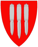
The coat-of-arms is from modern times. They were granted on 18 April 1986. The arms show three
knives as a symbol for the smithies and knife makers in the municipality. Knife making has long been a local tradition for which the village is well-known. [cite web|url=http://www.ngw.nl/int/nor/g/gjerstad.htm|author=Norske Kommunevåpen|date=1990|title=Nye kommunevåbener i Norden|accessdaymonth=3 October|accessyear=2008] see also2|Coat-of-arms of Vestre TotenHistory
Gjerstad was originally called "Visedal". Gjerstad has been inhabited from the
Stone Age and Viking Era through modern times.Agriculture has long been important, and until only decades ago the more marginal outfields in Upper Gjerstad were still utilized.Forestry also provided an important historic economic contribution, and logs were driven on rivers and streams in the municipality. To aid log transport by floating, numerousdam s were constructed. Eikeland Ironworks were a significant contribution to the economy as well.Geography
Gjerstad municipality has numerous glacially formed features, including a U-shaped valley, tarns and lakes. It is bordered in the north by
Nissedal ,Telemark andDrangedal , Telemark; in the east byKragerø , Telemark; in the south byRisør , Aust-Agder; and in the southwest byVegårshei , Aust-Agder.Attractions
* The remains of Eikeland Ironworks can still be seen in the upper valley. Gjerstad was famous for its beautiful handmade knives; the coat-of-arms recognizes this heritage.
* Holmen Farm ( _no. Holmen Gård) in upper Gjerstad is a Norwegian national center for handicraft.
* Horga is a pagan place of sacrifice which was destroyed by Olav Trygvason, which lies 300 meters from "Holmen Gård".Famous residents
Niels Henrik Abel (1802-1829), Norwegianmathematician , was the son of Søren Georg Abel. His grandfather, Hans Mathias Abel, served as minister to Gjerstad municipality from 1785 to 1804. His father became minister in Gjerstad in 1804, so Abel spent his boyhood in therectory at Gjerstad. Abel spent his last months at the nearbyFroland Verk.External links
* [http://www.gjerstad.org/ Gjerstad on the net] no icon
* [http://www.kulturnett.no/geografisknavigering/geografisknavigering_visning.jsp?fylke=T921062&kommune=T961580 Culture in Gjerstad on the map] no iconReferences
Wikimedia Foundation. 2010.