- Osogovo Monastery
-
Osogovo Monastery
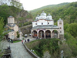
Osogovo Monastery with the Church of St. Joachim of Osogovo to the right and the Church of the Holy Mother of God to the leftMonastery information Order Macedonian Orthodox Established 12th century Dedicated to St Joachim and St Mary Diocese Diocese of Polog and Kumanovo Controlled churches Church of St Joachim
Church of the Holy Mother of GodPeople Founder(s) Teodor of Ovče Pole Site Location Kriva Palanka Municipality Public Access yes Osogovo Monastery (Macedonian: Осоговски Манастир) is a Macedonian Orthodox monastery located near Kriva Palanka, Republic of Macedonia, 10 kilometres (6.2 mi) from the Bulgarian border on Osogovo Mountain.[1] Osogovo Monastery is home to an art colony and to an architecture school during the summer.[1][2]
Contents
Description
The monastery consists of two churches including the larger "Saint Joachim of Osogovo" and the smaller "Holy Mother of God." The monastery grounds also consist of a bell tower, dormitories, a guardhouse, and a residency for the Head of the Macedonian Orthodox Church.[3]
The monastery was founded in the 12th century,[3] though there are no remains of the original monastery. The smaller church in today's monastery complex got its present look in the 14th century, while the larger one was built in the 19th century.[2]
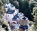
The larger, three-nave church, was built in 1851 by Andrey Damyanov. It has 12 cupolas, which represent the 12 apostles,[2] and porches on its southern and western sides. Most of the church's interior and cupolas were painted by Dimitar Andonov Papradiški. The smaller and older church, founded in the 12th century and rebuilt in the 14th century, is dedicated to the Holy Mother of God.[1]
Osogovo Monastery is situated 825 metres (2,707 feet) above sea level.[4]
History
The monastery was founded by a priest from Ovče Pole in the mid-12th century. In 1585, during Ottoman rule, the church was converted to mosque for a short period of time after the bey of Kriva Palanka renovated it, though it soon became a church again.[2]
During the Austro-Ottoman War of 1690, the monastery was severely damaged and was to be destroyed by the Ottomans as punishment to the locals for siding with the Austrians during the war. Legend claims that the Ottomans spared the church after becoming overpowered by some spiritual force.[2]
Gallery
-
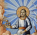
A fresco
References
- ^ a b c "The Monastery of St. Joachim of Osogovo, Kriva Palanka". British Council Bulgaria. Association for Cultural Tourism. 2010. http://heriquest.org/index.php?p=42&l=2&c=3&id=494. Retrieved April 16, 2010.
- ^ a b c d e Pg 249 - Evans, Thammy (2007). Macedonia, 2nd: The Bradt Travel Guide (2007 ed.). Bradt Travel Guides. ISBN 1841621862. http://books.google.com/books?id=4CpYot4N2PUC&printsec=frontcover&dq=bradt+travel+guide+macedonia&ei=sG27S-eQKIbEMdj41cEG&cd=1#v=onepage&q=Osogovo%20&f=false.- Total pages: 310
- ^ a b "Macedonia National Tourism Portal". Macedonia National Tourism Portal. 2010. http://www.exploringmacedonia.com/?ItemID=96C11FE14ACBD74A8F7F822BF1B3090A. Retrieved April 16, 2010.
- ^ "Monastery St. Joakim Of Osogovo". 360macedonia.com. 2010. http://www.360macedonia.com/en/Kriva-Palanka/st-joachim-of-osogovo-Monastery. Retrieved April 16, 2010.
Categories:- Christian monasteries in the Republic of Macedonia
- Macedonian Orthodox monasteries
Wikimedia Foundation. 2010.


