- Orolu
-
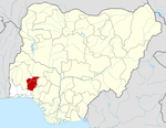
Orolu — LGA — Location in Nigeria
 Orolu
OroluCoordinates: 7°54′N 4°27′E / 7.9°N 4.45°ECoordinates: 7°54′N 4°27′E / 7.9°N 4.45°E Country  Nigeria
State Osun State Area – Total 80 km2 (30.9 sq mi) Population (2006 census) – Total 103,077 Time zone WAT (UTC+1) 3-digit postal code prefix 230 ISO 3166 code NG.OS.OR Orolu is a Local Government Area in Osun State, Nigeria. Its headquarters are in the town of Ifon (or Ifon Osun) at7°52′00″N 4°29′00″E / 7.8666667°N 4.4833333°E.
It has an area of 80 km² and a population of 103,077 at the 2006 census.
The postal code of the area is 230.[1]
References
- ^ "Post Offices- with map of LGA". NIPOST. http://www.nipost.gov.ng/PostCode.aspx. Retrieved 2009-10-20.
 Osun StateState capital: Osogbo
LGAs Aiyedaade · Aiyedire · Atakunmosa East · Atakunmosa West · Boluwaduro · Boripe · Ede North · Ede South · Egbedore · Ejigbo · Ife Central · Ife East · Ife North · Ife South · Ifedayo · Ifelodun · Ila · Ilesa East · Ilesa West · Irepodun · Irewole · Isokan · Iwo · Obokun · Odo Otin · Ola Oluwa · Olorunda · Oriade · Orolu · Osogbo
 Categories:
- Local Government Areas in Osun State
- Nigeria geography stubs


Wikimedia Foundation. 2010.