- Opperzau
-
Coordinates: 50°47′02″N 7°40′34″W / 50.784025°N 7.676218°W
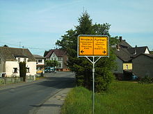 the "split" city limit sign on the Oppertsau side
Opperzau is a place of the German municipality Windeck in the Rhein-Sieg district in the south eastern part of North Rhine-Westphalia. The southern part of Opperzau is named Oppertsau which belongs to the municipality Fürthen and even belongs to Rhineland-Palatinate. It is located at the middle of the Sieg river.
History
In 1604 the settlement of Siegburg (Siegburger Vergleich) clarified the limit of the current federal states North Rhine-Westphalia and Rhineland-Palatinate which leads through the village and parted them into Opperzau (northern part) and Oppertsau (southern part). The reason was a dispute of a territorial sovereignty started in 1294, when the County of Sayn-Wittgenstein and some other small counties claimed possession over parts of Berg and the Sieg districts. And now, 200 meters of a road within the village marks the limit between both federal countries and have two different street names: Fürthener Straße for the Opperzau side, Siegstraße for the oppertsau side.
Traffic
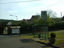 Bus stop Opperzau, school traffic only
The roads 112 and 267 leads along Opperzau to other parts of the Altenkirchen district and to districts of Windeck. The public transport is provided by bus transport company Wilhelm Marenbach having its headquartier in Opperzau. This bus line is concepted for school transport only so there is no later transport. Until 1993 Opperzau had a train stop which has been disused because of lack passenger frequentation.
Categories:- Rhein-Sieg district


Wikimedia Foundation. 2010.