Oppenhuizen

Oppenhuizen
Toppenhuzen
—  Village  —
Country Netherlands Netherlands
Province Friesland Friesland
Population
 - Total c. 1,130

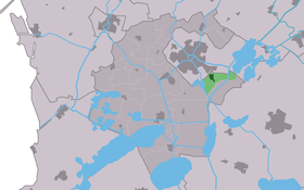
Oppenhuizen (West Frisian: Toppenhuzen) is a small village in Wymbritseradiel in the province Friesland of the Netherlands and has around 1135 citizens (2006).

Coordinates: 53°0′46″N 5°41′43″E / 53.01278°N 5.69528°E / 53.01278; 5.69528


Wikimedia Foundation. 2010.

Игры ⚽ Нужна курсовая?

Look at other dictionaries:

  • Oppenhuizen — 53°0′46″N 5°41′43″E / 53.01278, 5.69528 …   Wikipédia en Français

  • Oppenhuizen — Original name in latin Oppenhuizen Name in other language State code NL Continent/City Europe/Amsterdam longitude 53.01194 latitude 5.69495 altitude 0 Population 1150 Date 2012 04 14 …   Cities with a population over 1000 database

  • Toppenhuzen — Oppenhuizen 53°0′46″N 5°41′43″E / 53.01278, 5.69528 …   Wikipédia en Français

  • Wymbritseradiel — Infobox Settlement official name = Wymbritseradiel other name = Wymbritseradeel mapsize = 280px subdivision type = Country subdivision name = Netherlands subdivision type1 = Province subdivision name1 = Friesland area footnotes = (2006) area… …   Wikipedia

  • Kinderdijk — Coordinates: 51°53′N 4°38′E / 51.883°N 4.633°E / 51.883; 4.633 …   Wikipedia

  • List of places in the Netherlands — This is an alphabetical list of places (cities, towns, villages) in the Netherlands. Lists per province can be found at:* List of towns in Groningen * List of towns in Friesland * List of towns in Drente * List of towns in Overijssel * List of… …   Wikipedia

  • De Adriaan, Haarlem — Windmill De Adriaan De Adriaan is a windmill in the Netherlands that burnt down in 1932 and was rebuilt in 2002. The original windmill dates from 1779 and the mill has been a distinctive part of the skyline of Haarlem for centuries. Contents …   Wikipedia

  • Bryant High School (Arkansas) — Bryant High School (BHS) [http://www.bryantschools.org/ Bryant Homepage] is a secondary school in Bryant, Arkansas, United States. Bryant High School is located at latitude N 34.5987 and longitude W 92.49127.BHS, which covers grades 9 12, is a… …   Wikipedia

  • IJlst — Gemeinde Wymbritseradiel Flagge Wappen Provinz …   Deutsch Wikipedia

  • Wymbritseradeel — Gemeinde Wymbritseradiel Flagge Wappen Provinz …   Deutsch Wikipedia

Share the article and excerpts

Direct link
Do a right-click on the link above
and select “Copy Link”