- Old Bonalbo, New South Wales
-
Old Bonalbo
New South Wales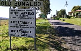
The entry signs to Old Bonalbo.
 Old Bonalbo
Population: 281 (2006 Census)[1] Postcode: 2470 Elevation: 195 m (640 ft) Location: LGA: Kyogle Council County: Buller State District: Lismore[2] Federal Division: Page Old Bonalbo is a rural village located 770 km north-east of Sydney, near Haystack Mountain in the Northern Rivers region of New South Wales, Australia. This village is on the Clarence Way between Bonalbo and Urbenville. This was the site of the original Bonalbo, the “Old” was added to its name in the early 1900s when a new settlement also called Bonalbo was built on the banks of Peacock Creek 11 kilometres to the south.
In the 1961 census Old Bonalbo had a population of 240 and in 2006 it was recorded as having 281 people resident. The town's name supposedly derives from the Gidabal word 'Bunawalbu' meaning 'bloodwood trees'.[3]
The first European settler in the area was J.D. McLean, a Scots settler who drove his sheep up from the Hunter Valley in 1841 when the depression struck. He established the 'Bunalbo' or Duck Creek run and later became a major pastoralist and the treasurer of Queensland. The Robertson Land Acts of 1861 opened the territories up to free selectors (small landowners) but it was not until 1887 that the first, Donald McIntyre, took up a section of the old station, although the Robertson family had selected various sections themselves, possibly prior to 1880. It was at this time that Australian red cedar-getters first moved into the area.
The Bonalbo village later developed on a part of McIntyre's holding which fronted on to Peacock Creek. However, the depression of the 1890s drove a number of selectors away, including McIntyre who sold his land to Paddy McNamee. New selectors appeared in the 1900s when McNamee proved the land was arable and when sawmills opened up west of the range.
Old Bonalbo has a general store that is also the post office. Beef cattle grazing is the main agricultural activity of the region. A number of timber plantations have been planted in the area.[4]
In January 2011 Old Bonalbo was isolated by floodwaters from Duck Creek which cut off the village and left many individual properties around the village isolated.
See also
References
- ^ Australian Bureau of Statistics (25 October 2007). "Old Bonalbo (Urban Centre/Locality)". 2006 Census QuickStats. http://www.censusdata.abs.gov.au/ABSNavigation/prenav/LocationSearch?collection=Census&period=2006&areacode=SSC18459&producttype=QuickStats&breadcrumb=PL&action=401. Retrieved 15 September 2011.
- ^ Electoral Commission NSW (4 April 2008). "LISMORE". http://www.elections.nsw.gov.au/state_government_elections/electoral_districts/all_districts_/lismore. Retrieved 15 September 2011.
- ^ "Bonalbo". Geographical Names Board of New South Wales. http://www.gnb.nsw.gov.au/name_search/extract?id=KWIOwpqb. Retrieved 20 June 2009.
- ^ Clean And Green - Villages - Oldbonalbo
Categories:- Towns in New South Wales
- Australian Aboriginal placenames


Wikimedia Foundation. 2010.