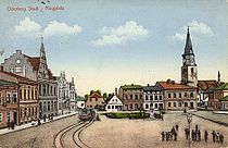
- Starý Bohumín
-
Starý Bohumín, lit. "Old Bohumín" (German: Alt Oderberg, Polish: Stary Bogumin) is a part of the town of Bohumín in Karviná District, Moravian-Silesian Region, Czech Republic. It has a population of 1,534 (August 2009).[1]
The settlement was first mentioned in a written document in 1256 as Bogun[2] and is the oldest part of todays town of Bohumín. Starý Bohumín lies on the Oder River, which forms a border with Poland. Before the construction of the Bohumín-Košice railway line, local inhabitants opposed train station to be built in their town. The construction was moved a few kilometres southeastward, and Starý Bohumín gradually lost its importance.
See also
Footnotes
- ^ Population statistics of Bohumín
- ^ Hosák et al. 1970, 84-85.
References
- Description of the village
- Hosák, Ladislav; and Rudolf Šrámek (1970). Místní jména na Moravě a ve Slezsku I, A-L. Praha: Academia.

This Moravian-Silesian Region location article is a stub. You can help Wikipedia by expanding it. Categories:- Cities and towns in the Czech Republic
- Neighbourhoods in the Czech Republic
- Karviná District
- Cieszyn Silesia
- Moravian-Silesian Region geography stubs
Wikimedia Foundation. 2010.
Look at other dictionaries:
Stary Bohumin — Original name in latin Star Bohumn Name in other language Bogumin, Bohumin, Bohumn, Oderberg, Stary Bohumin, Star Bohumn State code CZ Continent/City Europe/Prague longitude 49.9169 latitude 18.33619 altitude 200 Population 23034 Date 2012 01 19 … Cities with a population over 1000 database
Bohumín — Bohumín … Deutsch Wikipedia
Bohumin — Bohumín … Deutsch Wikipedia
Bohumín — Infobox City official name = Bohumín native name = nickname = settlement type = Town motto = image caption = image shield = Bogumin CoA.svg pushpin pushpin label position = none pushpin map caption = Location in the Czech Republic subdivision… … Wikipedia
Nový Bohumín — Masaryk Square and the town hall in Nový Bohumín Nový Bohumín, lit. New Bohumín (Polish: Nowy Bogumin) is a part of the town of Bohumín in Karviná District, Moravian Silesian Region, Czech Republic. It has a pop … Wikipedia
List of German exonyms for places in the Czech Republic — Below are links to subpages with more detailed listings of the German language names of towns and villages in different regions of the Czech Republic. Many of these German names are now exonyms, but used to be endonyms commonly used by the local… … Wikipedia
Liste deutscher Bezeichnungen tschechischer Orte — In dieser Liste werden deutschen (heute großteils nicht mehr geläufigen) topografischen Namen die tschechischen, amtlichen Pendants gegenübergestellt. Durch die Vertreibungen nach 1945 wurden viele kleinere Orte und Gehöfte, insbesondere in… … Deutsch Wikipedia
Tworków — Hilfe zu Wappen … Deutsch Wikipedia
D 1 — Basisdaten Gesamtlänge 376,5 km (297 km D1, 80 km D47) im Betrieb: 264,8 km (247,6 km D1, 17,2 km D47) im Bau: 31 km (4 km als D1, 27 km als D47) in Planung: 82 km (46 km als D1, 36 km als D47) Ausbauzustand 2/3 Fahrspuren mit Standsp … Deutsch Wikipedia
Liste der Straßenbahnen in Europa — Dieser Artikel wurde zur Löschung vorgeschlagen. Falls du Autor des Artikels bist, lies dir bitte durch, was ein Löschantrag bedeutet, und entferne diesen Hinweis nicht. Zur Löschdiskussion Begründung: Vorlage:Löschantragstext/AprilSiehe… … Deutsch Wikipedia

