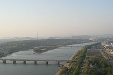
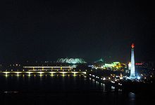
- Okryu Bridge
-
Coordinates: 39°1′30″N 125°45′40″E / 39.025°N 125.76111°E
Okryu Bridge 
From the top of the Juche Tower facing north, the Okryu Bridge is in the foreground, with Rungra Islet and Moran Hill behind itKorean name Chosŏn'gŭl 옥류교 Hancha 玉流橋 McCune–Reischauer Ongnyugyo Revised Romanization Ongnyugyo  The Okryu Bridge (centre) at night, with the Juche Tower visible on the right
The Okryu Bridge, also spelled Ongnyu Bridge, is a bridge on the Taedong River in Pyongyang, North Korea. Construction began in March 1958; the bridge was opened in August 1960.[1]
Location
Located between the Rungra Bridge and Taedong Bridge, it is one of six Pyongyang bridges on the Taedong. It connects Chung-guyok on the Taedong's right (west) bank to Taedonggang-guyok on the left bank.[2] The famous restaurant Okryugwan is near its right foot, while the Juche Tower is located just south of its left foot.[1]
Construction
The Okryu Bridge is a prestressed concrete box girder bridge.[2] It is variously reported to be 680 or 700 metres long, and 28.5 metres wide, with four lanes for cars.[1][2]
References
- ^ a b c "평양 옥류교 건설 뒷얘기 [The story after the construction of Pyongyang's Okryu Bridge]", Daily NK, 2006-01-31, http://www.dailynk.com/korean/read.php?cataId=nk09000&num=18051, retrieved 2010-07-02
- ^ a b c "옥류교 [Okryu Bridge]", Doosan Encyclopedia, http://www.encyber.com/search_w/ctdetail.php?masterno=851310&contentno=851310, retrieved 2010-07-02

This article about transport in North Korea is a stub. You can help Wikipedia by expanding it.
