Oinafa

Oinafa
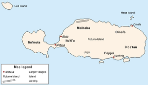
Map showing districts of Rotuma

Oinafa is one of the seven districts on the island of Rotuma, a dependency of Fiji. It includes the villages of Oinafa, Lopta, and Paptea.[1]

References

  1. ^ "Oinafa". Rotuma.net. http://www.rotuma.net/os/Districts/oinafa.htm. Retrieved 10 June 2010. 


Wikimedia Foundation. 2010.

Игры ⚽ Поможем решить контрольную работу

Look at other dictionaries:

  • Rotuma — This article is about the Fijian dependancy. For other uses, see Rotuma (disambiguation). Rotuma Island (Fijian dependency) Rotuma …   Wikipedia

  • Solkope — is a small island off the southern coast of Rotuma in the Fiji Islands. It is considered to be part of Rotuma along with the several other minor islands: Hatana, Hofliua, Solnohu, and Uea.ecessionist movementIn 2000 Solkope was the subject of a… …   Wikipedia

  • Gagaja — (IPA Pronunciation: /ŋəŋəʧə/) is a Rotuman word denoting the position of “Chief” or “Lord”. This could be a formal chiefly position in one of the seven districts (“gagaj ‘es itu’u”) or a village chief (“fa ‘es ho’aga”) as well as to anyone else,… …   Wikipedia

  • Rotuma Island — ▪ island, Fiji       island dependency of Fiji, South Pacific Ocean, 400 miles (640 km) north northwest of Suva. Rotuma is a volcanic island surrounded by eight islets. Sighted in 1791 by the British naval ship Pandora during its search for the… …   Universalium

  • Noa’tau — Map showing districts of Rotuma Noa tau is one of the seven districts on the island of Rotuma, a dependency of Fiji. It includes the villages of Maragteu and Fekeoko.[1] Noa tau is the most easterly district on the island. Because Rotuma s… …   Wikipedia

  • Itu'tiu — is the physically largest of the seven districts on the island of Rotuma, a Dependency of the Republic of Fiji. Its name means Big District in the Rotuman language, and is traditionally ranked third in terms of chiefly precedence, determined by… …   Wikipedia

  • FJ-R — Rotuma mit Distrikten und wichtigsten Dörfern Lage Rotumas …   Deutsch Wikipedia

  • Rotuma (Fidschi) — Rotuma Geographie Staat: Fidschi Gewässer: Pazifischer Ozean Inseln …   Deutsch Wikipedia

  • Malhaha — Map showing districts of Rotuma Malhaha is one of the seven districts on the island of Rotuma, a dependency of Fiji. It includes the villages of Pepheua, Else e, and Elsio.[1] It is here that Raho, the founder of Rotuma, established his residence …   Wikipedia

Share the article and excerpts

Direct link
Do a right-click on the link above
and select “Copy Link”