- Nußhardt
-
Nußhardt Height 972 m above sea level (3,189 ft) Location Bavaria,  Germany
Range Fichtelgebirge Coordinates 50°03′33″N 11°53′06″E / 50.05917°N 11.885°ECoordinates: 50°03′33″N 11°53′06″E / 50.05917°N 11.885°E 

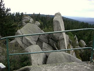
Observation platform on the Nußhardt looking towards Seehaus
At 972 m above sea level the Nußhardt is the third highest mountain in the Fichtelgebirge Mountains in the south German state of Bavaria. It lies in the far northeast of the state and has a rocky summit characteristic of the Fichtelgebirge (coarse-grained Kern Granite G3 and augen gneiss at the southeast end). The summit area with its felsenmeer and tor is a nature reserve with an area of 5.5 hectares (14 acres). In addition the Nußhardt is incorporated into the geotope register of the Bavarian State Geological Department under No. 472R013.
Contents
Location
The Nußhardt lies on the FGV's main hill trail between the FGV hostel of Seehaus and the Schneeberg, the highest mountain in the range. The climbing area is looked after by the local FGV branch at Vordorf.
Legends
On the rocky viewing point there are eight, small, bowl-shaped hollows in the granite; so-called druid bowls. In former centuries they were believed to be the sacrifice bowls for heathen cults. Today it is known that they are a special form of weathering in the granite. It is also worth mentioning the so-called Nußhardtstube ('Nußhardt parlour'), a roughly 50 m long covered chamber, whose low entrance is on the southern side of the rocks.
Name
In the records of the Berneck office in 1536 the Nußhardt appears as Nusser, and again in a margraviate forest inspection report of 1536. Its spelling in the records and literature varies: Nusser, Nosser, Nußhardt – there has been no lack of interpretations for these names, but none has been really convincing.
Climbing area
As early as 1880 the first steps to the highest point of the Nußhardt tor were erected by te Fichtelgebirge Branch of the German-Austrian Alpine Club to give "better views" of the Schneeberg, Ochsenkopf, the Fichtelsee, the Franconian Jura and the Kemnather Land.
Sources
- Herrmann, Detmar : Lexikon Fichtelgebirge, Ackermann Verlag Hof/Saale
- Der Siebenstern, Vereinszeitschrift des Fichtelgebirgsvereins e. V., Theresienstraße 2, 95632 Wunsiedel
Maps:
- Fritsch Wanderkarte 1:50.000
External links
Johann Wolfgang von Goethe was on the Nußhardt in the Fichtelgebirge
Categories:- Mountains under 1000 metres
- Mountains of Bavaria
- Mountains of the Fichtelgebirge


Wikimedia Foundation. 2010.