Numan — can refer to: Places Ma arat al Numan, a small western Syrian market city Ma arrat al Numan District Siege of Ma arrat al Numan in 1098 during the First Crusade Numan, Nigeria A town in Adamawa State People Ahmad Muhammad Numan (1909 1996), twice … Wikipedia
Numan — ▪ Nigeria town and port on the Benue River, Adamawa state, eastern Nigeria. It is located about 30 miles (50 km) from Yola, opposite the mouth of the Gongola River, which is the principal tributary of the Benue River. Numan is connected by… … Universalium
Nigeria — Nigerian, adj., n. /nuy jear ee euh/, n. a republic in W Africa: member of the Commonwealth of Nations; formerly a British colony and protectorate. 107,129,469; 356,669 sq. mi. (923,773 sq. km). Cap.: Abuja. Official name, Federal Republic of… … Universalium
Yola, Nigeria — Infobox Settlement official name =Yola other name = native name = nickname = settlement type = motto = imagesize = 200px image caption = Yola town,and in the background the mountains flag size = image seal size = image shield = shield size =… … Wikipedia
Bali language (Nigeria) — Infobox Language name=Bali region=Numan, Adamawa, Nigeria speakers=2,000 (as of 1991) familycolor=Niger Congo fam2=Atlantic Congo fam3=Volta Congo fam4=North fam5=Adamawa Ubangi fam6=Adamawa fam7=Leko Nimbari fam8=Mumuye Yandang fam9=Yandang iso2 … Wikipedia
Zone de gouvernement local au nigeria — Pour les articles homonymes, voir LGA. Zones de gouvernement local du Nigeria Les zones de gouvernem … Wikipédia en Français
Local Government Areas of Nigeria — Local Government Areas of Nigeria … Wikipedia
Zone de gouvernement local au Nigeria — Pour les articles homonymes, voir LGA. Zones de gouvernement local du Nigeria Les zones de gouvernement local (Local Government Area ou LGA) sont des subdivisions des … Wikipédia en Français
Local Government Areas in Nigeria — Die Local Government Areas Nigerias in der Übersicht Die Verwaltungsgliederung von Nigeria teilt die Bundesrepublik Nigeria seit 1996 in 774 Local Government Areas (LGA) ein. Nachfolgend sind alle LGA in alphabetischer Reihenfolge sowie, in… … Deutsch Wikipedia
Yola (Nigeria) — Yola Basisdaten Bundesstaat Adamawa Koordinaten 9° 14′ N, 12° 28′ O … Deutsch Wikipedia
 Numan
Numan Nigeria
 Adamawa StateState capital: Yola
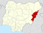 Categories:
