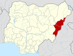
- Michika
-
Michika
Mwecika— LGA and town — Motto: Land of Triple Heritage Coordinates: 10°37′5″N 13°23′22″E / 10.61806°N 13.38944°ECoordinates: 10°37′5″N 13°23′22″E / 10.61806°N 13.38944°E Country  Nigeria
State Adamawa State Time zone WAT (UTC+1) Michika is a Local Government Area of Adamawa State, Nigeria. The principal tribe and language in Michika is the Kamwe. Michika local government was created in 1976. It is located in the northern axis of the state and is bordered on the East by the Republic of Cameeroon. Michika is made of eight districts. Michika is the corrupted form of Mwecika which is the Kamwe Language for "creeping in silently". Oral history has it that Michika was founded by one Kwada Kwaka around late 1700. Kwada Kwaka was a hunter who came to hunt on the Michika hills. Michika is a local government headquarters. It has branches of many banks, a college of health technology, a technical college and many secondary schools. Michika town is traversed by a stream called Wathara. There are many cultural festivals performed by the Kamwe people in Michika foremost amongst them are the Yawale, Wasinata and the Ngarba dance. The incumbent Governor of the state is Murtala Nyako.
Major Languages
Higgi and Marghi
 Adamawa StateState capital: Yola
LGAs Demsa · Fufore · Ganye · Guyuk · Gombi · Girei · Hong · Jada · Lamurde · Madagali · Maiha · Mayo Belwa · Michika · Mubi North · Mubi South · Numan · Shelleng · Song · Toungo · Yola North · Yola South
 Categories:
- Local Government Areas in Adamawa State
- Populated places in Adamawa State
- Nigeria geography stubs
Wikimedia Foundation. 2010.

