- Nugent Island
-
Nugent Island 
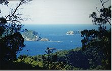
Nugent Island (In the Trees) Near Raoul Island.
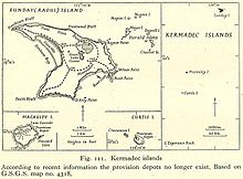
MapGeography Coordinates 29°13′54″S 177°52′09″W / 29.23167°S 177.86917°W Archipelago Kermadec Islands Country Demographics Population 0 Nugent Island is the most northerly island in the Kermadec Islands and the most northerly territory in New Zealand. It lies to the northeast of New Zealand. It is circular and approximately 100 metres (109 yd) across.
The island is one of the group to the northeast of Raoul Island. Coordinates: 29°13′54″S 177°52′09″W / 29.23167°S 177.86917°W
See also
Kermadec Islands Cheeseman Island · Curtis Island · L'Esperance Rock · Macauley Island · Nugent Island · Raoul (Sunday) Island
 Categories:
- Kermadec Islands
- Uninhabited islands of New Zealand
- New Zealand outlying island geography stubs
Wikimedia Foundation. 2010.
