- Nossa Senhora da Tourega (Évora)
-
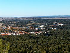
Nossa Senhora da Tourega Civil Parish (Freguesia) A vista of the village of Valverde, as seen from the Castle of Giraldo, Nossa Senhora da TouregaOfficial name: Freguesia de Nossa Senhora da Tourega Country  Portugal
Region Alentejo Subregion Alentejo Central District Évora Municipality Évora Center Nossa Senhora da Tourega - elevation 195 m (640 ft) - coordinates 38°27′19.09″N 8°1′18.28″W / 38.4553028°N 8.0217444°W Length 14.02 km (9 mi), Northwest-Southeast Width 27.17 km (17 mi), Southwest-Northeast Area 196.17 km2 (76 sq mi) LAU Freguesia/Junta Freguesia - location Rua Geraldo S. Pavor, Nossa Senhora da Tourega, Évora President Junta Joaquim António Filipe Pimpão President Assembleia José Carlos Correia Flamino Timezone WET (UTC0) - summer (DST) WET (UTC+1) ISO 3166-2 code PT- Postal Zone 7000-092 Valverde Area Code & Prefix (+351) 266 XXX XXX Patron Saint Nossa Senhora da Assunção Parish Address Rua Geraldo S. Pavor
7000-092 ValverdeWikimedia Commons: Nossa Senhora da Tourega Statistics: Instituto Nacional de Estatística[1] Website: http://www.evora.net/jfnstourega/ Geographic detail from CAOP (2010)[2] produced by Instituto Geográfico Português (IGP) Nossa Senhora da Tourega is a civil parish in the municipality of Évora, with an area of 196.17 km² and a 2001 population of approximately 804 inhabitants.
Contents
History
In 1864, then known as Ourega, the parish had approximately 576 inhabitants. By 1878, that figure had grown to 688 inhabitants, when it was now commonly referred to as Tourega (Nossa Senhora da Assunção).
Between 1911 and 1920 the parish was annexed to the neighbouring parish of Nossa Senhora da Graça do Divor, which was only remedied on 18 October 1926 (Decree-Law No.12/509). The census of 1930 identified a population of 1186 habitants, which in 1936 included the parish of São Brás do Regedouro.
Until 22 August 2003, it was known as Nossa Senhora da Torega.
Geography
Nossa Senhora da Tourega, is a rural civil parish in the municipality of Évora, with its parish seat in the village of Valverde. Access to this community is accomplished through the EN 380 (Évora-Alcáçovas).
Architecture
Prehistoric
- Anta Grande do Zambujeiro, a prehistoric dolmen, excavated near the northern border, considered one of the largest remaining dolmens in the Iberian Peninsula, and excavated in 1958, to the discovery of prehistoric slabs, copper artefacts and ceramics, now on exhibition in the Museum of Évora;
- Anta do Barrocal
- Cromlech of Almendres
- Megalithic monuments of Vale de Rodrigo
Archaeological
- Roman villa of Tourega
Religious
- Convent of Bom Jesus de Valverde
References
- Notes
- ^ INE, ed. (2010) (in Portuguese), Censos 2011 - Resultadas Preliminares [2011 Census - Preliminary Results], Lisbon, Portugal: Instituto Nacional de Estatística, http://www.ine.pt/xportal/xmain?xpid=INE&xpgid=ine_publicacoes&PUBLICACOESpub_boui=122114780&PUBLICACOESmodo=2, retrieved 1 July 2011
- ^ IGP, ed. (2010) (in Portuguese), Carta Administrativa Oficial de Portugal, Lisbon, Portugal: Instituto Geográfico Português, http://www.igeo.pt/produtos/cadastro/caop/download/Areas_Freg_Mun_Dist_CAOP2010.zip, retrieved 1 July 2011
Categories:- Parishes of Évora
- Parishes of Portugal
Wikimedia Foundation. 2010.


