- Severnaya Sosva River
-
Severnaya Sosva (Северная Сосьва) River Country Russia Region Khanty-Mansi Autonomous Okrug Part of Ob River Tributaries - left Lyapin, Vogulka - right Lesser Sosva, Tapsuy City Berezovo Length 754 km (469 mi) Width 1 km (1 mi) Discharge - average 860 m3/s (30,371 cu ft/s) The Severnaya Sosva (Russian: Северная Сосьва) is a river in Khanty-Mansi Autonomous Okrug, Russia, which drains the northern Ural Mountains into the lower Ob River.
Geography
The river and its tributaries are basically T-shaped. The Khulga and Lyapin Rivers flow south for about 125 miles parallel to the Urals while the main Northern Sosva flows about 125 miles northward. The united rivers then flow east southeast about 100 miles almost to the Ob near Igrim and then flow north about 50 miles before joining the Ob at Beryozovo. Its headwaters are just east of the headwaters of the Pechora River on the other side of the Urals and somewhat north of the headwaters of the southeast-flowing Pelym River.
Its length is 754 kilometres, the area of its basin is 98,300 km2 and the average flow of the river is 860 m3. It is frozen between November and April and floods (mostly snowmelt) from May to September. Like many rivers in the West Siberian Plain, it has an extensive flood plain with marshes and meanders. In spring the area near the Ob often floods. The channel width sometimes approaches 1 kilometre and the flood plain 40km. The river is navigable by ships in the lower region.
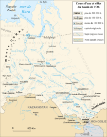 The Northern Sosva in the Ob Basin - double click to expand
There are two Malaya Sosva Rivers.[citation needed] The larger flows north to join the Northern Sosva near Igrim. The other joins the Bolshaya Sosva to form the Northern Sosva.
Trade Route
There was some ill-documented Russian trade in the area before the Russian conquest of Siberia. After about 1593 the Northern Sosva was one of the main routes into Siberia (for the others, see Verkhoturye). The route ran from the Pechora River, up the Shchugor River, over either of two passes and down the Sosva to the Ob River and the fur-rich Mangazeya region. By the late seventeenth century the fur trade declined and most trade shifted south to Verkhoturye and some north to the Usa River.
References
- Большая Советская Энциклопедия (Russian)
Categories:- Rivers of Khanty-Mansi Autonomous Okrug

Wikimedia Foundation. 2010.