Nieuwmarkt metro station

Nieuwmarkt metro station
Nieuwmarkt
Nieuwmarkt metro 2.jpg
Station statistics
Address Nieuwmarkt, Amsterdam,
 Netherlands
Coordinates 52°22′20″N 4°54′03″E / 52.37222°N 4.90083°E / 52.37222; 4.90083Coordinates: 52°22′20″N 4°54′03″E / 52.37222°N 4.90083°E / 52.37222; 4.90083
Lines 51, 53, 54
Platforms 2
Tracks 2
Other information
Opened 11 October 1980
Owned by GVB
Fare zone 5700 (Centrum)
OV-chipkaart Required
Services
Preceding station   Amsterdam Metro   Following station
Terminus
Line 51
Waterlooplein
toward Westwijk
Terminus
Line 53
Waterlooplein
toward Gaasperplas
Terminus
Line 54
Waterlooplein
toward Gein

Nieuwmarkt is an Amsterdam Metro station in the centre of Amsterdam, The Netherlands.

The Station

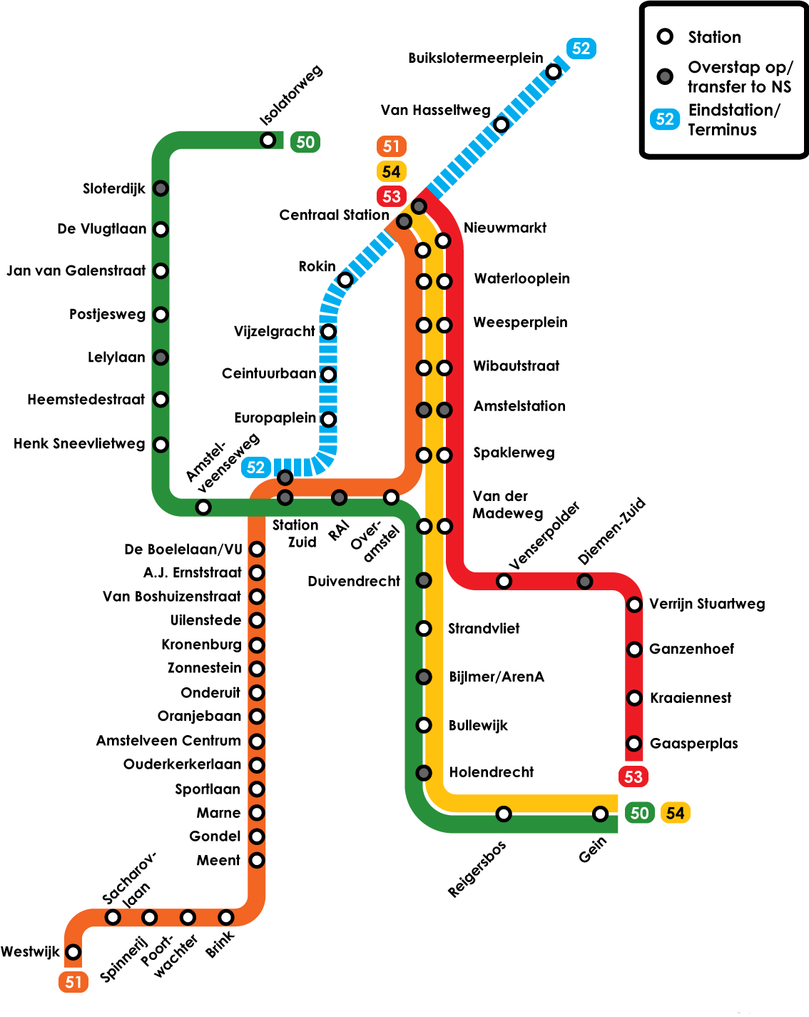
Nieuwmarkt Metro station opened in 1980 and is served by 3 lines, the 51 (Amsterdam Centraal - Amstelveen), 53 (Amsterdam Centraal - Gaasperplas) and 54 (Amsterdam Centraal - Gein).

The station lies close to the Weigh House (De Waag) of Amsterdam.

The metro station is only accessible with an OV-chipkaart or GVB Travel Pass.

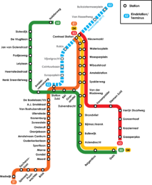
Amsterdam Metro network

References


Wikimedia Foundation. 2010.

Игры ⚽ Нужен реферат?

Look at other dictionaries:

  • Overamstel metro station — Overamstel Station statistics Address Overamstel, Amsterdam …   Wikipedia

  • Nieuwmarkt — Formerly a gate and weighing house,The Waag currently houses a cafe/restaurant …   Wikipedia

  • Nieuwmarkt — Der Nieuwmarkt (deutsch: Neumarkt) ist ein Platz (niederländisch: Plein) und Wohnviertel in der Innenstadt von Amsterdam mit zahlreichen Restaurants, Geschäften, Cafés, Bars, einem Warenmarkt und dem Rijksmonument De Waag. Inhaltsverzeichnis 1… …   Deutsch Wikipedia

  • Diemen Zuid railway station — Diemen Zuid Station statistics Coordinates …   Wikipedia

  • Duivendrecht railway station — Duivendrecht Station statistics Coordinates …   Wikipedia

  • Liste des stations du métro d'Amsterdam — Pour les articles homonymes, voir Ligne 50, Ligne 51, Ligne 53 et Ligne 54. Article principal : Métro d Amsterdam …   Wikipédia en Français

  • Amsterdam Metro — Infobox Public transit name = Amsterdam Metro imagesize = locale = Amsterdam transit type = Mixed rapid transit and light rail began operation = 1977 ended operation = system length = Rapid transit: km to mi|32.7|precision=1|abbr=yes Total: km to …   Wikipedia

  • NH Grand Hotel Krasnapolsky (Amsterdam) — NH Grand Hotel Krasnapolsky country: Netherlands, city: Amsterdam (City Centre Dam Square) NH Grand Hotel Krasnapolsky Location Located in the city centre in the heart of Amsterdam, overlooking the famous National Monument on the Dam Square and… …   International hotels

  • Amsterdam — This article is about the Dutch capital. For other uses, see Amsterdam (disambiguation). Amsterdam   Municipality/city   From left to right and top to bot …   Wikipedia

  • Transportation in Amsterdam — is a selection of ways of transportation in and around Amsterdam. Transportation within the city itself is characterized by bicycles and public transportation. Large freeways only exist around the city, terminating at the A10 Ringroad. Navigating …   Wikipedia

Share the article and excerpts

Direct link
Do a right-click on the link above
and select “Copy Link”