- Nghĩa Tá
-
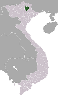
Nghĩa Tá — Commune and village — Country  Vietnam
Province Bắc Kạn Province District Chợ Đồn District Time zone UTC+7 (UTC+7) Nghĩa Tá is a commune (xã) and village in Chợ Đồn District, Bắc Kạn Province, in Vietnam.
 Bắc Kạn ProvinceCapital:Bắc Kạn
Bắc Kạn: Wards: Nguyễn Thị Minh Khai · Đức Xuân · Sông Cầu · Phùng Chí Kiên Communes: · Huyền Tụng · Dương Quang · Nông Thượng · Xuất Hóa
Ba Bể District: Bạch Thông District: Phủ Thông · Phương Linh · Vi Hương · Tú Trĩ · Lục Bình · Đôn Phong · Dương Phong · Quang Thuận · Hà Vị · Quân Bình · Cẩm Giàng · Tân Tiến · Sĩ Bình · Vũ Muộn · Cao Sơn · Nguyên Phúc · Mỹ ThanhChợ Đồn District: Chợ Mới District: Chợ Mới · Quảng Chu · Yên Đĩnh · Như Cố · Bình Văn · Yên Hân · Yên Cư · Thanh Bình · Nông Hạ · Nông Thịnh · Cao Kỳ · Tân Sơn · Hòa Mục · Thanh Vận · Thanh Mai · Mai LạpNa Rì District: Ngân Sơn District: Pác Nặm District: Bằng Thành · Nhạn Môn · Công Bằng · Giáo Hiệu · Bộc Bố · Xuân La · Cổ Linh · An Thắng · Cao Tân · Nghiên LoanCategories:- Bắc Kạn Province geography stubs
- Populated places in Bac Kan Province
- Communes of Bac Kan Province
Wikimedia Foundation. 2010.