- Lizumer Reckner
-
Lizumer Reckner 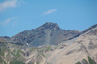
The Lizumer Reckner from the south
Height 2,886 m AA (9,469 ft) Location Tyrol,  Austria
Range Tux Alps Coordinates 47°08′39″N 11°37′50″E / 47.1440778°N 11.6305194°ECoordinates: 47°08′39″N 11°37′50″E / 47.1440778°N 11.6305194°E 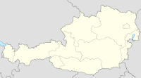

Type rock summit Rock serpentinite 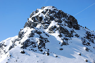
The Lizumer Reckner from the north
The Lizumer Reckner is, at 2,886 m AA,[1] the highest mountain in the Tux Alps in the Austrian state of Tyrol.
Contents
Location and area
The Lizumer Reckner lies in the centre of the Tux Alps, about 20 kilometres southeast of Innsbruck within the Lizum Walchen Training Area (Truppenübungsplatz Lizum Walchen). To the west lies the Navis valley, to the southeast the Schmirn valley and to the east the Wattener Lizum. The Tuxertal valley lies not far to the southeast. It neighbouring mountain to the south is the Geier. To the north a mountain crest runs to the Lizumer Sonnenspitze, the Tarntaler Köpfe and eventually as far as the Mölsberg. To the west of the Lizumer Reckner is the 2,824 m high Naviser Reckner (47°08′39″N 11°37′27″E / 47.14417°N 11.62417°E).[1]
Geology
The Reckner lies on the edge of the Tauern window, a region of the Eastern Alps, in which Penninic nappes and possibly also Helvetic nappes are exposed. The summit block of the Reckner consists of serpentinite, which is mainly embedded in radiolarite. Furthermore, in the geologically diverse surrounding area dolomite breccias, kalkschiefer and other rocks of the Jurassic period.[2]
Below the summit block of the Reckner there are stone runs, that are seen as the remains of a former rock glacier. Traces of dead ice may also be found here.[3]
Bases and trails
From the Navis valley (Navistal) the mountain may be climbed inter alia from the Naviser Hut (1,767 m) or the Peeralm (1,663 m). In the Schmirn valley (Schmirntal) the hamlet of Obern acts as a departure point. From the Tuxertal the Reckner can be ascended from the 1,984 m high Junsbergalm or from Hintertux. The most important base in the Wattener Lizum is the Lizumer Hut (2,019 m).[1]
The southern foot of the summit block can be reached from all these bases over a number of marked hiking trails.[1] The climb from the Lizum is also possible in winter as a ski tour. The final climb to the summit requires some easy climbing and is partly secured as a Klettersteig.[4]
Due to its location within the military training area, ascents of the mountain are banned from time to time.[5]
References
- ^ a b c d Bundesamt für Eich- und Vermessungswesen: Österreichische Karte 1:50.000, AMAP Online, accessed on 13 April 2011
- ^ F. K. Bauer, Geologische Bundesanstalt (ed.): Der geologische Aufbau Österreichs. Springer, 24 October 2011, ISBN 9783211815564, p. 307 (Google Books ; as at: 2011-04-14).
- ^ Christian Dingeldey, Geologische Bundesanstalt (ed.): Bericht 1998 über geologische Aufnahmen im Quartär der Tarntaler Berge auf Blatt 149 Lanersbach. p. 305 (http://www.geologie.ac.at/filestore/download/JB1423_304_A.pdf ; as at: 2011-04-14).
- ^ Sepp Brandl, Gerhard Hirtlreiter: Kitzbüheler Alpen, Tuxer und Zillertaler Alpen: Brixental, Spertental, Windau, Kelchsau, Wildschönau, Alpbachtal, Zillertal, Tuxer Tal, Hochfügen, Weerberg, Wattener Lizum. 50 Skitouren im Tiroler Unterland, zwischen Inntal und Pass Thurn, Hochfügen und Gerlos Bergverlag Rother, 24 October 2011, ISBN 9783763359103, p. 95 (Google Books ; as at: 2011-04-14).
- ^ Gemeinde Wattenberg, accessed on 14 April 2011
Sources
Sepp Brandl, Gerhard Hirtlreiter: Kitzbüheler Alpen, Tuxer und Zillertaler Alpen: Brixental, Spertental, Windau, Kelchsau, Wildschönau, Alpbachtal, Zillertal, Tuxer Tal, Hochfügen, Weerberg, Wattener Lizum. 50 Skitouren im Tiroler Unterland, zwischen Inntal und Pass Thurn, Hochfügen und Gerlos Bergverlag Rother, 24 October 2011, ISBN 9783763359103, p. 95 (Google Books ; as at: 2011-04-14).
External links
Categories:- Two-thousanders
- Mountains of the Alps
- Mountains of Tyrol
- Tux Alps


Wikimedia Foundation. 2010.