Jihovýchod

Jihovýchod
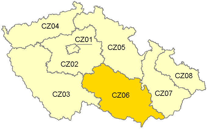
Jihovýchod
—  NUTS2 Region  —
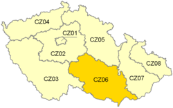
Country  Czech Republic
Capital city
Area
 – Total 13,990 km2 (5,401.6 sq mi)
Population
 – Total 1,641,372
Time zone CET (UTC+1)
 – Summer (DST) CEST (UTC+2)
GDP
GDP/capita

Jihovýchod (Southeast) is statistical area of the Nomenclature of Territorial Units for Statistics, level NUTS 2. It is create by Vysočina Region and South Moravian Region.

It covers an area of 13 990 km² and live there 1,641,372 inhabitants (population density 117 inhabitants/km²).

See also

NUTS of the Czech Republic


Wikimedia Foundation. 2010.

Игры ⚽ Поможем написать реферат

Look at other dictionaries:

  • NUTS Jihovýchod — (Southeast) is statistical area of Eurostat, level NUTS 2. It is create by Vysočina Region and South Moravian Region.It covers an area of 13 990 km² and live there 1 641 372 inhabitants (population density 117 inhabitants/km²). Segmentation ee… …   Wikipedia

  • CZ-NUTS — Die Statistikregionen des NUTS Systems in Tschechien umfassen eine räumliche Bezugseinheit der Hierarchieebene NUTS 1, acht der Ebene NUTS 2 und 14 der Ebene NUTS 3. Die NUTS Statistikregionen wurden 1999 in Tschechien eingeführt.… …   Deutsch Wikipedia

  • NUTS:CZ — Die Statistikregionen des NUTS Systems in Tschechien umfassen eine räumliche Bezugseinheit der Hierarchieebene NUTS 1, acht der Ebene NUTS 2 und 14 der Ebene NUTS 3. Die NUTS Statistikregionen wurden 1999 in Tschechien eingeführt.… …   Deutsch Wikipedia

  • NUTS of the Czech Republic — Main article: Nomenclature of Territorial Units for Statistics In the NUTS (Nomenclature of Territorial Units for Statistics) codes of the Czech Republic (CZ), the three levels are: Level Subdivisions # NUTS 1 1 NUTS 2 Oblasts (Oblasti) 8 NUTS 3… …   Wikipedia

Share the article and excerpts

Direct link
Do a right-click on the link above
and select “Copy Link”