N-234 road (Spain)

N-234 road (Spain)

 N-234 

Carretera Nacional N-234
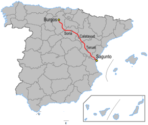
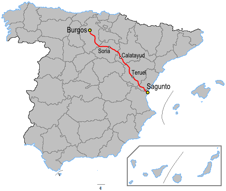
Route information
Length: 482 km (300 mi)
Major junctions
From: Sagunt
To: Burgos
Highway system

National roads in Spain

The N-234 is a highway in Spain. It connects Sagunto to Burgos across the Iberian System.[1]

The road starts 9 km south of Burgos on the Autovía A-1. It heads south east through the Sierra de las Mamblas rising over the Mazariegos (1,060m) and pass Muela (1,374m). It continues through the mountains tom Soria passing over the Puerto Mojón Pardo (1,234m) with the Reserva Nacional de Urbión in the Sierra de Urbión to the north rising to 2,229m. This range is also the source of the Duero River.

At Soria the road meets the N-111 and N-122. The road continues south east into the Sierra de la Virgen and the Puerto Bigornia (1,100m). At Calatayud there is a junction with the Autovía A-2. The road follows the Jiloca River to Daroca and a junction with the N-330 crossing the Puerto de Villafeliche (860m).

The road continues along the rio Jiloca River valley with the road being upgraded to the Autovía A-23. It is crossed by the N-211. The road passes over the Alto de Cella (1,013m) near Cella before dropping into Teruel. Here the N-330 branches off to the south.

The road rises to cross the Puerto de Escandón (1,242m) and the Sierra de Camarena. The road passes between the Serra d'Espadà and Sierra de Javalambre arriving at the coast at Sagunto and the Autopista AP-7.

In 2002 an airplane fell on N-234 road in the Torres Torres municipal term.[2]

References

External links

Coordinates: 39°47′28″N 0°20′57″W / 39.79111°N 0.34917°W / 39.79111; -0.34917


Wikimedia Foundation. 2010.

Игры ⚽ Поможем написать курсовую

Look at other dictionaries:

  • N-111 road (Spain) —  N 111  Carretera Nacional N 111 Route information Length: 260 km (160 mi) …   Wikipedia

  • N-122 road (Spain) —  N 122  Carretera Nacional N 122 Route information Length: 115 km (71 mi) Major junctions From: Soria …   Wikipedia

  • N-120 road (Spain) —  N 120  Carretera Nacional N 120 Route information Length: 662 km (411 mi) …   Wikipedia

  • N-420 road (Spain) —  N 420  Carretera Nacional N 420 Route information Length: 803 km (499 mi) Major junctions From: Montoro …   Wikipedia

  • N-110 road (Spain) —  N 110  Carretera Nacional N 110 Route information Length: 376 km (234 mi) …   Wikipedia

  • N-330 road (Spain) —  N 330  Carretera Nacional N 330 Route information Length: 733 km (455 mi) …   Wikipedia

  • List of autopistas and autovías in Spain — The Spanish motorway network is the fourth largest in the world by length, after the United States, China and Canada. As of 2008, there are 15,152 km (9,415 mi) of High Capacity Roads[1] (Sp. Vías de Gran Capacidad) in the country.… …   Wikipedia

  • N-234 — National Road in Spain Name= Carretera Nacional N 234 Signal= N 234 Beginning= Sagunt End= Burgos Length= 482The N 234 is a highway in Spain. It connects Sagunto to Burgos.The road starts 9km south of Burgos on the Autovía A 1. It heads south… …   Wikipedia

  • Elland Road — Infobox Stadium stadium name = Elland Road nickname = caption = The East Stand façade, bearing the club s name and crest. fullname = Elland Road Stadium location = Elland Road (A643) Beeston Leeds West Yorkshire ENG coordinates =… …   Wikipedia

  • Teruel & Province (Spain) — Hotels: Albarracin Hotel (Province: Albarracin) Parador de Alcaniz Teruel Province (Province: Alcaniz) Parador de Teruel (Outer City: Road N 234) Reina Cristina Hotel Teruel (City: Centre) Sercotel Plaza Boulevard Hotel Teruel (Ci …   International hotels

Share the article and excerpts

Direct link
Do a right-click on the link above
and select “Copy Link”