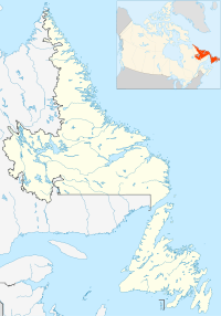
- Murray's Harbour, Newfoundland and Labrador
-
Location of Murray's Harbour in Newfoundland and Labrador
Murray's Harbour is a settlement in Newfoundland and Labrador.
Coordinates: 52°27′22″N 55°40′55″W / 52.456°N 55.682°W / 52.456; -55.682

This Labrador location article is a stub. You can help Wikipedia by expanding it.v · Categories: - Populated places in Labrador
- Labrador geography stubs
Wikimedia Foundation. 2010.
Look at other dictionaries:
St. John's, Newfoundland and Labrador — Not to be confused with Saint John, New Brunswick. St. John s City … Wikipedia
List of communities in Newfoundland and Labrador — This page lists communities of the province of Newfoundland and Labrador, Canada. Incorporated towns or cities are recognized as census subdivisions by Statistics Canada and can be found on List of cities and towns in Newfoundland and Labrador.… … Wikipedia
Newfoundland Railway — Reporting mark NFLD Locale Newfoundland Dates of operation 1898–1949 (merged into CN), aban … Wikipedia
Newfoundland expedition — For other military actions involving Newfoundland, see Newfoundland expedition (disambiguation). Newfoundland expedition Part of the French Revolutionary Wars … Wikipedia
Newfoundland Tricolour — Flag of Pink, White and Green (unofficial) Name The Pink, White and Green Proportion 1:2 Design A vertical tricolour of green, whit … Wikipedia
Newfoundland general election, 1893 — The 18th Newfoundland general election was held on 6 November 1893 to elect members of the 17th General Assembly of Newfoundland in the Dominion of Newfoundland. Although the Liberals won the majority of seats, the Tory party filed petitions… … Wikipedia
Newfoundland general election, 1889 — The 17th Newfoundland general election was held on 6 November 1889 to elect members of the 16th General Assembly of Newfoundland in the Dominion of Newfoundland. The Reform Party administration of Robert Thorburn was defeated in favour of the… … Wikipedia
Newfoundland Royal Commission — The Newfoundland Royal Commission or Amulree Commission (as it came to be known) was a royal commission established on February 17, 1933 by the Government of the United Kingdom to examine into the future of Newfoundland and in particular to… … Wikipedia
Terra Nova (Terre-Neuve-et-Labrador) — Parc national de Terra Nova Parc national de Terra Nova Catégorie II de la CMAP (Parc national) Pays Canada Province … Wikipédia en Français
List of Sea Cadet Corps in Canada — The List of Sea Cadet Corps in Canada is a list of the individual Sea Cadet Corps by unit number, giving unit name and location. Corps may be removed, created, or restored if there are not enough/more than enough cadets attending.Corp #, Name,… … Wikipedia
18+© Academic, 2000-2024- Contact us: Technical Support, Advertising
Dictionaries export, created on PHP, Joomla, Drupal, WordPress, MODx.Share the article and excerpts
Murray's Harbour, Newfoundland and Labrador
- Murray's Harbour, Newfoundland and Labrador
-
Location of Murray's Harbour in Newfoundland and Labrador
Murray's Harbour is a settlement in Newfoundland and Labrador.
Coordinates: 52°27′22″N 55°40′55″W / 52.456°N 55.682°W

This Labrador location article is a stub. You can help Wikipedia by expanding it.

