- Muiryfold
-
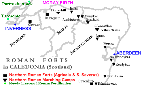
 The Muiryfold and the Roman fort of Cawdor are located near Inverness. They were considered between the northernmost places of Roman conquest and presence in Britannia, until the recent discovery of Roman military presence at Tarradale & Portmahomack.
Muiryfold was one of the Roman fortifications built by Septimius Severus in northern Caledonia (modern-day Scotland). The site is located 6 kilometres (3.7 mi) east of Keith in Moray.
Contents
History
In 210 AD, the Emperor Septimius Severus made an attempt to conquer all Caledonia reaching the Moray Firth. He created a huge marching camp at Muiryfold,[1] near the one created in 84 AD by Agricola at Auchinhove.[2]
It is one of the most northerly known Roman forts in the British Isles, together with Cawdor.[3] The possibility that Agricola and Septimius Severus reached the northernmost area of Scotland can be confirmed by discoveries north of Inverness, specifically at Portmahomack on the Dornoch Firth,[4] and Tarradale on the north shore of the Beauly Firth.[5]
The Roman legions in the first and second century established a chain of very large forts at Ardoch, Strageath, Inchtuthil, Battledykes, Stracathro and Raedykes,[6] taking the Elsick Mounth on the way to Normandykes before going north to Glenmailen, Bellie, Balnageith and Cawdor.
Notes
- ^ Aerial photos of Muiryfold
- ^ RCAHMS: Muiryfold
- ^ Roman fort near Inverness
- ^ RCAHMS: Port A'Chaistell
- ^ Google Book: Tarradale, a possible roman camp. p. 176
- ^ The Roman Gask Project
Bibliography
- Frere, S. Britannia: a History of roman Britain. Londra, 1998. ISBN 0-7126-5027-X
- Hanson, W S (1980) The first Roman occupation of Scotland, in Hanson, W S and Keppie, L J F Roman Frontier studies 1979: Papers presented to the 12th International Congress of Roman Frontier Studies, Brit Archaeol Rep, International, vol.S71, 1 Oxford 15-43
- Moffat, Alistair. Before Scotland: The Story of Scotland Before History. Thames & Hudson. Londra, 2005. ISBN 050005133X
- St Joseph, J K (1961) Air reconnaissance in Britain, 1958-60, J Roman Stud, vol.51 123
See also
- Cawdor (Roman Fort)
- Deers Den
- Inchtuthil
- Pennymuir Roman camps
- Normandykes
- Ythan Wells
- Gask Ridge
Coordinates: 57°33′10″N 2°51′36″W / 57.55278°N 2.86°W
This Ancient Rome-related article is a stub. You can help Wikipedia by expanding it.